Spáta geodata
Spáta (Attica) is a seat of a third-order administrative division; located in Greece in Europe/Athens (GMT+3) time zone. With population of 9,198 people, there are 155 cities with bigger population in this country. Compared to other cities in Greece, 75.5% of cities are located further ↑North; 76.5% of cities are located further ←West and 65.5% of cities have lower elevation than Spáta. Note1
Administrative division(s):
- Level 1: Attica
- Level 2: Nomarchía Anatolikís Attikís
- Level 3: Dimos Spata-Artemida


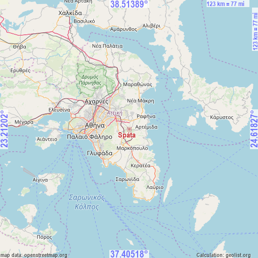
Spáta GPS coordinates[2]
37° 57' 41.868" North, 23° 54' 54.504" East
| Map corner | latitude | longitude |
|---|---|---|
| Upper-left | 38.51389°, | 23.21202° |
| Center: | 37.96163°, | 23.91514° |
| Lower-right: | 37.40518°, | 24.61827° |
| Map W x H: | 123.3×123.3 km | = 76.6×76.6mi |
| max Lat: | 41.72048° ⇑75.5% North |
| Spáta: | 37.96163° |
| min Lat: | ⇓24.5% South 34.8346° |
| min Long | Spáta | max Long |
| 19.40494° | 23.91514° | 29.59361° |
| W 76.5%⇐ | ⇒23.5% E |
Elevation
Elevation of Spáta is 142 m = 466 ft, and this is 26.9 m = 88 ft below average elevation for this country.
| Max E: |
1439 m = 4721 ft | 34.5% |
| Avg. | 168.9 m = 554 ft | |
| Spáta | 142 m = 466 ft | |
Min E: |
0 m = 0 ft | 65.5% |
See also: Greece elevation on elevation.city.
Geographical zone
Spáta is located in North temperate zone (between Tropic of Cancer and the Arctic Circle). Distance of this Northern Tropic circle is 1615 km =1003.5 mi to South.| Distance of | km | miles | from Spáta |
|---|---|---|---|
| North Pole | 5786.1 | 3595.3 | to North |
| Arctic Circle | 3180.2 | 1976.1 | to North |
| Tropic Cancer | 1615 | 1003.5 | to South |
| Equator | 4220.9 | 2622.7 | to South |


Nearby cities:
15 places around Spáta: (largest is in red/bold)
• Agia Kyriakií Spáton
6.5 km =4 mi,  57°
57°
• Anthoúsa
7.9 km =4.9 mi,  334°
334°
• Argithéa
3 km =1.9 mi,  299°
299°
• Artémida
7.2 km =4.5 mi,  84°
84°
• Christoúpoli
1.9 km =1.2 mi,  7°
7°
• Dhráfi
6.9 km =4.3 mi,  354°
354°
• Dióni
7 km =4.3 mi, 12°
• Kallitechnoúpoli
8.1 km =5 mi,  27°
27°
• Karellás
5.3 km =3.3 mi,  235°
235°
• Koropí
7.9 km =4.9 mi,  208°
208°
• Leondárion
6 km =3.7 mi, 298°
• Neápoli Spáton
5.6 km =3.5 mi,  85°
85°
• Paianía
5.4 km =3.4 mi,  262°
262°
• Pallíni
5.6 km =3.5 mi, 329°
• Pikérmi
5 km =3.1 mi, 26°
Sources, notices
• [Note1] Compared only with cities in Greece existing in our database
• [Src1] Map data: © OpenStreetMap contributors (CC-BY-SA)
• [Src2] Other city data from geonames.org with taken over terms of usage.
• [Src3] Geographical zone / Annual Mean Temperature by Robert A. Rohde @ Wikipedia
