Martínon geodata
Martínon (Central Greece) is a populated place; located in Greece in Europe/Athens (GMT+3) time zone. With population of 1,916 people, there are 543 cities with bigger population in this country. Compared to other cities in Greece, 60.5% of cities are located further ↑North; 58.7% of cities are located further ←West and 76.9% of cities have lower elevation than Martínon. Note1


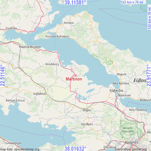
Martínon GPS coordinates[2]
38° 34' 5.412" North, 23° 12' 52.488" East
| Map corner | latitude | longitude |
|---|---|---|
| Upper-left | 39.11581°, | 22.51146° |
| Center: | 38.56817°, | 23.21458° |
| Lower-right: | 38.01632°, | 23.91771° |
| Map W x H: | 122.3×122.3 km | = 76×76mi |
| max Lat: | 41.72048° ⇑60.5% North |
| Martínon: | 38.56817° |
| min Lat: | ⇓39.5% South 34.8346° |
| min Long | Martínon | max Long |
| 19.40494° | 23.21458° | 29.59361° |
| W 58.7%⇐ | ⇒41.3% E |
Elevation
Elevation of Martínon is 231 m = 758 ft, and this is 62.1 m = 204 ft above average elevation for this country.
| Max E: |
1439 m = 4721 ft | 23.1% |
| Martínon | 231 m 758 ft | |
| Avg. | 168.9 m = 554 ft | |
Min E: |
0 m = 0 ft | 76.9% |
See also: Greece elevation on elevation.city.
Geographical zone
Martínon is located in North temperate zone (between Tropic of Cancer and the Arctic Circle). Distance of this Northern Tropic circle is 1682.5 km =1045.5 mi to South.| Distance of | km | miles | from Martínon |
|---|---|---|---|
| North Pole | 5718.7 | 3553.4 | to North |
| Arctic Circle | 3112.8 | 1934.2 | to North |
| Tropic Cancer | 1682.5 | 1045.5 | to South |
| Equator | 4288.4 | 2664.7 | to South |


Nearby cities:
15 places around Martínon: (largest is in red/bold)
• Akraifnía
12.4 km =7.7 mi,  177°
177°
• Alíartos
24.5 km =15.2 mi,  203°
203°
• Arkítsa
25.1 km =15.6 mi,  321°
321°
• Atalánti
20.9 km =13 mi,  296°
296°
• Kástron
9.5 km =5.9 mi,  209°
209°
• Kókkinon
10.6 km =6.6 mi,  168°
168°
• Livanátes
21.3 km =13.2 mi, 318°
• Loukísia
22.6 km =14 mi,  115°
115°
• Lárimna
6.1 km =3.8 mi,  92°
92°
• Límni
23.8 km =14.8 mi,  21°
21°
• Malesína
6.2 km =3.9 mi, 15°
• Orchomenós
22.1 km =13.7 mi,  247°
247°
• Roviés
26.9 km =16.7 mi,  2°
2°
• Tragána
9.8 km =6.1 mi,  305°
305°
• Éxarkhos
23.6 km =14.7 mi,  275°
275°
Sources, notices
• [Note1] Compared only with cities in Greece existing in our database
• [Src1] Map data: © OpenStreetMap contributors (CC-BY-SA)
• [Src2] Other city data from geonames.org with taken over terms of usage.
• [Src3] Geographical zone / Annual Mean Temperature by Robert A. Rohde @ Wikipedia
