Kiáto geodata
Kiáto (Peloponnese) is a seat of a third-order administrative division; located in Greece in Europe/Athens (GMT+3) time zone. With population of 9,812 people, there are 145 cities with bigger population in this country. Compared to other cities in Greece, 73.3% of cities are located further ↑North; 53.4% of cities are located further →East and 89.2% of cities have higher elevation than Kiáto. Note1


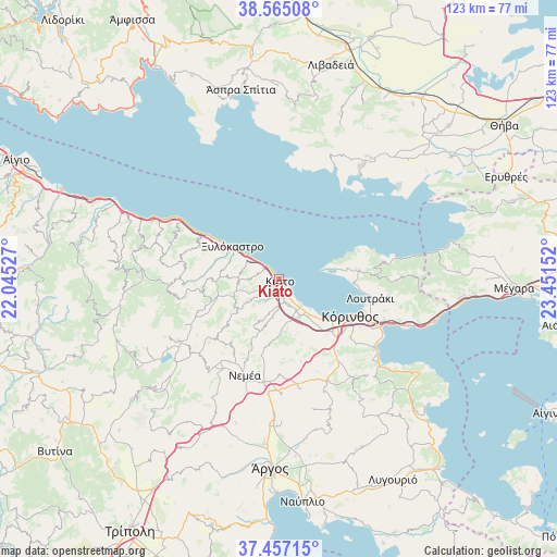
Kiáto GPS coordinates[2]
38° 0' 47.556" North, 22° 44' 54.204" East
| Map corner | latitude | longitude |
|---|---|---|
| Upper-left | 38.56508°, | 22.04527° |
| Center: | 38.01321°, | 22.74839° |
| Lower-right: | 37.45715°, | 23.45152° |
| Map W x H: | 123.2×123.2 km | = 76.6×76.6mi |
| max Lat: | 41.72048° ⇑73.3% North |
| Kiáto: | 38.01321° |
| min Lat: | ⇓26.7% South 34.8346° |
| min Long | Kiáto | max Long |
| 19.40494° | 22.74839° | 29.59361° |
| W 46.6%⇐ | ⇒53.4% E |
Elevation
Elevation of Kiáto is 9 m = 30 ft, and this is 159.9 m = 525 ft below average elevation for this country.
| Max E: |
1439 m = 4721 ft | 89.2% |
| Avg. | 168.9 m = 554 ft | |
| Kiáto | 9 m = 30 ft | |
Min E: |
0 m = 0 ft | 10.8% |
See also: Greece elevation on elevation.city.
Geographical zone
Kiáto is located in North temperate zone (between Tropic of Cancer and the Arctic Circle). Distance of this Northern Tropic circle is 1620.8 km =1007.1 mi to South.| Distance of | km | miles | from Kiáto |
|---|---|---|---|
| North Pole | 5780.4 | 3591.8 | to North |
| Arctic Circle | 3174.5 | 1972.5 | to North |
| Tropic Cancer | 1620.8 | 1007.1 | to South |
| Equator | 4226.7 | 2626.3 | to South |


Nearby cities:
15 places around Kiáto: (largest is in red/bold)
• Boláti
7.4 km =4.6 mi,  149°
149°
• Kokkónion
5.5 km =3.4 mi, 149°
• Krínes
5.4 km =3.4 mi,  168°
168°
• Káto Dhiminió
1.9 km =1.2 mi,  313°
313°
• Káto Ássos
10.2 km =6.3 mi,  135°
135°
• Melíssi
6.8 km =4.2 mi,  304°
304°
• Moúlki
3 km =1.9 mi,  222°
222°
• Nerántza
4.4 km =2.7 mi, 137°
• Poullítsa
6.4 km =4 mi,  161°
161°
• Pásion
1.8 km =1.1 mi,  269°
269°
• Sikyón
4 km =2.5 mi,  211°
211°
• Vokhaïkó
8.2 km =5.1 mi, 152°
• Vrakháti
7.9 km =4.9 mi, 140°
• Vélo
4.2 km =2.6 mi, 166°
• Zevgolateió
10 km =6.2 mi, 153°
Sources, notices
• [Note1] Compared only with cities in Greece existing in our database
• [Src1] Map data: © OpenStreetMap contributors (CC-BY-SA)
• [Src2] Other city data from geonames.org with taken over terms of usage.
• [Src3] Geographical zone / Annual Mean Temperature by Robert A. Rohde @ Wikipedia
