Filótion geodata
Filótion (South Aegean) is a populated place; located in Greece in Europe/Athens (GMT+3) time zone. With population of 1,477 people, there are 676 cities with bigger population in this country. Compared to other cities in Greece, 89.6% of cities are located further ↑North; 90.9% of cities are located further ←West and 84.9% of cities have lower elevation than Filótion. Note1
Administrative division(s):
- Level 1: South Aegean
- Level 2: Nomós Kykládon
- Level 3: Dimos Naxos and Lesser Cyclades


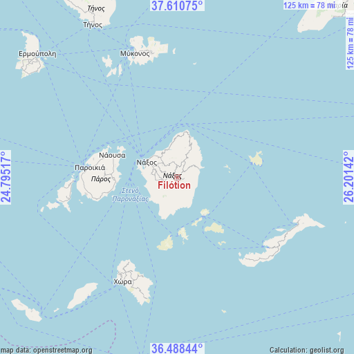
Filótion GPS coordinates[2]
37° 3' 6.012" North, 25° 29' 53.844" East
| Map corner | latitude | longitude |
|---|---|---|
| Upper-left | 37.61075°, | 24.79517° |
| Center: | 37.05167°, | 25.49829° |
| Lower-right: | 36.48844°, | 26.20142° |
| Map W x H: | 124.8×124.8 km | = 77.5×77.5mi |
| max Lat: | 41.72048° ⇑89.6% North |
| Filótion: | 37.05167° |
| min Lat: | ⇓10.4% South 34.8346° |
| min Long | Filótion | max Long |
| 19.40494° | 25.49829° | 29.59361° |
| W 90.9%⇐ | ⇒9.1% E |
Elevation
Elevation of Filótion is 372 m = 1220 ft, and this is 203.1 m = 666 ft above average elevation for this country.
| Max E: |
1439 m = 4721 ft | 15.1% |
| Filótion | 372 m 1220 ft | |
| Avg. | 168.9 m = 554 ft | |
Min E: |
0 m = 0 ft | 84.9% |
See also: Greece elevation on elevation.city.
Geographical zone
Filótion is located in North temperate zone (between Tropic of Cancer and the Arctic Circle). Distance of this Northern Tropic circle is 1513.8 km =940.6 mi to South.| Distance of | km | miles | from Filótion |
|---|---|---|---|
| North Pole | 5887.3 | 3658.2 | to North |
| Arctic Circle | 3281.4 | 2039 | to North |
| Tropic Cancer | 1513.8 | 940.6 | to South |
| Equator | 4119.8 | 2559.9 | to South |


Nearby cities:
15 places around Filótion: (largest is in red/bold)
• Amorgós
43.1 km =26.8 mi,  124°
124°
• Antíparos
36.9 km =22.9 mi,  267°
267°
• Apérathos
2.9 km =1.8 mi,  40°
40°
• Glinádo
8.8 km =5.5 mi,  284°
284°
• Kóronos
8.1 km =5 mi,  24°
24°
• Náousa
24.2 km =15 mi,  288°
288°
• Náxos
12.4 km =7.7 mi,  298°
298°
• Ornós
44.2 km =27.5 mi,  339°
339°
• Platýs Gialós
42.6 km =26.5 mi, 341°
• Plintrí
43.3 km =26.9 mi, 343°
• Páros
31.1 km =19.3 mi, 276°
• Vívlos
8 km =5 mi, 275°
• Ágios Arsénios
9.5 km =5.9 mi, 276°
• Áno Merá
45.2 km =28.1 mi,  347°
347°
• Íos
40.2 km =25 mi,  208°
208°
Sources, notices
• [Note1] Compared only with cities in Greece existing in our database
• [Src1] Map data: © OpenStreetMap contributors (CC-BY-SA)
• [Src2] Other city data from geonames.org with taken over terms of usage.
• [Src3] Geographical zone / Annual Mean Temperature by Robert A. Rohde @ Wikipedia
