Pappadhátai geodata
Pappadhátai (West Greece) is a populated place; located in Greece in Europe/Athens (GMT+3) time zone. With population of 1,077 people, there are 939 cities with bigger population in this country. Compared to other cities in Greece, 61% of cities are located further ↑North; 83.7% of cities are located further →East and 51.2% of cities have higher elevation than Pappadhátai. Note1
Administrative division(s):
- Level 1: West Greece
- Level 2: Nomós Aitolías kai Akarnanías
- Level 3: Dimos Agrinio


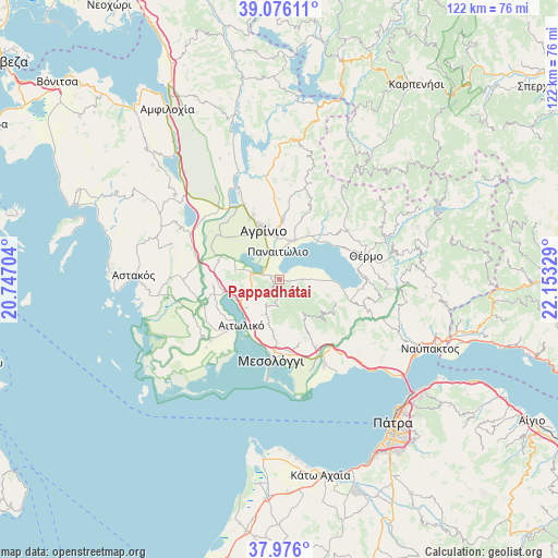
Pappadhátai GPS coordinates[2]
38° 31' 41.376" North, 21° 27' 0.576" East
| Map corner | latitude | longitude |
|---|---|---|
| Upper-left | 39.07611°, | 20.74704° |
| Center: | 38.52816°, | 21.45016° |
| Lower-right: | 37.976°, | 22.15329° |
| Map W x H: | 122.3×122.3 km | = 76×76mi |
| max Lat: | 41.72048° ⇑61% North |
| Pappadhátai: | 38.52816° |
| min Lat: | ⇓39% South 34.8346° |
| min Long | Pappadhátai | max Long |
| 19.40494° | 21.45016° | 29.59361° |
| W 16.3%⇐ | ⇒83.7% E |
Elevation
Elevation of Pappadhátai is 76 m = 249 ft, and this is 92.9 m = 305 ft below average elevation for this country.
| Max E: |
1439 m = 4721 ft | 51.2% |
| Avg. | 168.9 m = 554 ft | |
| Pappadhátai | 76 m = 249 ft | |
Min E: |
0 m = 0 ft | 48.8% |
See also: Greece elevation on elevation.city.
Geographical zone
Pappadhátai is located in North temperate zone (between Tropic of Cancer and the Arctic Circle). Distance of this Northern Tropic circle is 1678 km =1042.7 mi to South.| Distance of | km | miles | from Pappadhátai |
|---|---|---|---|
| North Pole | 5723.1 | 3556.2 | to North |
| Arctic Circle | 3117.2 | 1936.9 | to North |
| Tropic Cancer | 1678 | 1042.7 | to South |
| Equator | 4283.9 | 2661.9 | to South |


Nearby cities:
15 places around Pappadhátai: (largest is in red/bold)
• Agrínio
11 km =6.8 mi,  340°
340°
• Aitolikó
13.2 km =8.2 mi,  219°
219°
• Dhokímion
11.2 km =7 mi,  327°
327°
• Gavaloú
7.1 km =4.4 mi,  89°
89°
• Grammatikoú
4.8 km =3 mi, 90°
• Kainoúryion
9.1 km =5.7 mi,  21°
21°
• Kamaroúla
11.3 km =7 mi,  357°
357°
• Mataránga
2.1 km =1.3 mi,  104°
104°
• Néa Avórani
8.9 km =5.5 mi, 358°
• Panaitólion
6.1 km =3.8 mi, 357°
• Pandánassa
12.3 km =7.6 mi,  48°
48°
• Paravóla
11.4 km =7.1 mi,  32°
32°
• Zevgarákion
3.3 km =2.1 mi,  286°
286°
• Áyios Andréas
9 km =5.6 mi, 91°
• Áyios Konstandínos
12.5 km =7.8 mi, 339°
Sources, notices
• [Note1] Compared only with cities in Greece existing in our database
• [Src1] Map data: © OpenStreetMap contributors (CC-BY-SA)
• [Src2] Other city data from geonames.org with taken over terms of usage.
• [Src3] Geographical zone / Annual Mean Temperature by Robert A. Rohde @ Wikipedia
