Pandánassa geodata
Pandánassa (West Greece) is a populated place; located in Greece in Europe/Athens (GMT+3) time zone. With population of 531 people, there are 1737 cities with bigger population in this country. Compared to other cities in Greece, 59.9% of cities are located further ↑North; 81.9% of cities are located further →East and 70% of cities have higher elevation than Pandánassa. Note1
Administrative division(s):
- Level 1: West Greece
- Level 2: Nomós Aitolías kai Akarnanías
- Level 3: Dimos Agrinio


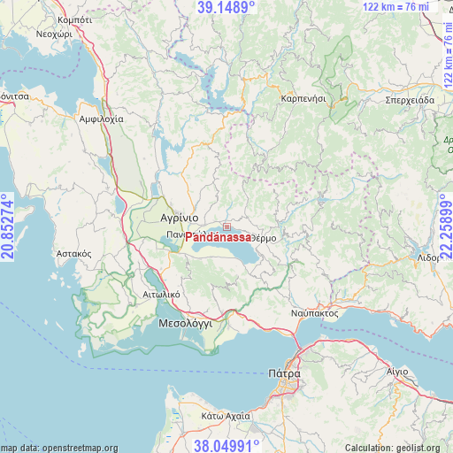
Pandánassa GPS coordinates[2]
38° 36' 5.436" North, 21° 33' 21.096" East
| Map corner | latitude | longitude |
|---|---|---|
| Upper-left | 39.1489°, | 20.85274° |
| Center: | 38.60151°, | 21.55586° |
| Lower-right: | 38.04991°, | 22.25899° |
| Map W x H: | 122.2×122.2 km | = 75.9×75.9mi |
| max Lat: | 41.72048° ⇑59.9% North |
| Pandánassa: | 38.60151° |
| min Lat: | ⇓40.1% South 34.8346° |
| min Long | Pandánassa | max Long |
| 19.40494° | 21.55586° | 29.59361° |
| W 18.1%⇐ | ⇒81.9% E |
Elevation
Elevation of Pandánassa is 31 m = 102 ft, and this is 137.9 m = 452 ft below average elevation for this country.
| Max E: |
1439 m = 4721 ft | 70% |
| Avg. | 168.9 m = 554 ft | |
| Pandánassa | 31 m = 102 ft | |
Min E: |
0 m = 0 ft | 30% |
See also: Greece elevation on elevation.city.
Geographical zone
Pandánassa is located in North temperate zone (between Tropic of Cancer and the Arctic Circle). Distance of this Northern Tropic circle is 1686.2 km =1047.8 mi to South.| Distance of | km | miles | from Pandánassa |
|---|---|---|---|
| North Pole | 5715 | 3551.1 | to North |
| Arctic Circle | 3109.1 | 1931.9 | to North |
| Tropic Cancer | 1686.2 | 1047.8 | to South |
| Equator | 4292.1 | 2667 | to South |


Nearby cities:
15 places around Pandánassa: (largest is in red/bold)
• Agrínio
13.1 km =8.1 mi,  279°
279°
• Gavaloú
8.3 km =5.2 mi,  194°
194°
• Grammatikoú
9.3 km =5.8 mi,  208°
208°
• Kainoúryion
5.9 km =3.7 mi,  273°
273°
• Kamaroúla
10.1 km =6.3 mi,  288°
288°
• Káto Makrinoú
14.1 km =8.8 mi,  154°
154°
• Mataránga
11.3 km =7 mi,  219°
219°
• Néa Avórani
9.4 km =5.8 mi, 274°
• Panaitólion
9.7 km =6 mi,  257°
257°
• Pappadhátai
12.3 km =7.6 mi,  228°
228°
• Paravóla
3.4 km =2.1 mi,  295°
295°
• Thérmo
10.1 km =6.3 mi,  107°
107°
• Zevgarákion
14.3 km =8.9 mi,  239°
239°
• Áyios Andréas
8.4 km =5.2 mi,  181°
181°
• Áyios Konstandínos
14 km =8.7 mi, 284°
Sources, notices
• [Note1] Compared only with cities in Greece existing in our database
• [Src1] Map data: © OpenStreetMap contributors (CC-BY-SA)
• [Src2] Other city data from geonames.org with taken over terms of usage.
• [Src3] Geographical zone / Annual Mean Temperature by Robert A. Rohde @ Wikipedia
