Melíssi geodata
Melíssi (Peloponnese) is a populated place; located in Greece in Europe/Athens (GMT+3) time zone. With population of 832 people, there are 1227 cities with bigger population in this country. Compared to other cities in Greece, 71.7% of cities are located further ↑North; 55.6% of cities are located further →East and 65.2% of cities have higher elevation than Melíssi. Note1
Administrative division(s):
- Level 1: Peloponnese
- Level 2: Nomós Korinthías
- Level 3: Dimos Xylokastro-Evrostina


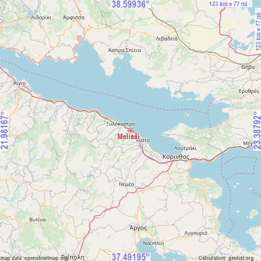
Melíssi GPS coordinates[2]
38° 2' 51.9" North, 22° 41' 5.244" East
| Map corner | latitude | longitude |
|---|---|---|
| Upper-left | 38.59936°, | 21.98167° |
| Center: | 38.04775°, | 22.68479° |
| Lower-right: | 37.49195°, | 23.38792° |
| Map W x H: | 123.1×123.1 km | = 76.5×76.5mi |
| max Lat: | 41.72048° ⇑71.7% North |
| Melíssi: | 38.04775° |
| min Lat: | ⇓28.3% South 34.8346° |
| min Long | Melíssi | max Long |
| 19.40494° | 22.68479° | 29.59361° |
| W 44.4%⇐ | ⇒55.6% E |
Elevation
Elevation of Melíssi is 39 m = 128 ft, and this is 129.9 m = 426 ft below average elevation for this country.
| Max E: |
1439 m = 4721 ft | 65.2% |
| Avg. | 168.9 m = 554 ft | |
| Melíssi | 39 m = 128 ft | |
Min E: |
0 m = 0 ft | 34.8% |
See also: Greece elevation on elevation.city.
Geographical zone
Melíssi is located in North temperate zone (between Tropic of Cancer and the Arctic Circle). Distance of this Northern Tropic circle is 1624.6 km =1009.5 mi to South.| Distance of | km | miles | from Melíssi |
|---|---|---|---|
| North Pole | 5776.5 | 3589.3 | to North |
| Arctic Circle | 3170.7 | 1970.2 | to North |
| Tropic Cancer | 1624.6 | 1009.5 | to South |
| Equator | 4230.5 | 2628.7 | to South |


Nearby cities:
15 places around Melíssi: (largest is in red/bold)
• Boláti
13.8 km =8.6 mi,  137°
137°
• Kamári
10.3 km =6.4 mi,  299°
299°
• Kariótika Karyás
3.7 km =2.3 mi, 298°
• Kiáto
6.8 km =4.2 mi,  124°
124°
• Kokkónion
12 km =7.5 mi, 135°
• Krionérion
10.3 km =6.4 mi,  204°
204°
• Krínes
11.3 km =7 mi, 143°
• Káto Dhiminió
4.9 km =3 mi, 121°
• Moúlki
7 km =4.3 mi,  149°
149°
• Nerántza
11.1 km =6.9 mi,  129°
129°
• Poullítsa
12.4 km =7.7 mi, 142°
• Pásion
5.4 km =3.4 mi, 135°
• Sikyón
8.1 km =5 mi, 154°
• Vélo
10.3 km =6.4 mi, 140°
• Xylókastro
5.7 km =3.5 mi,  305°
305°
Sources, notices
• [Note1] Compared only with cities in Greece existing in our database
• [Src1] Map data: © OpenStreetMap contributors (CC-BY-SA)
• [Src2] Other city data from geonames.org with taken over terms of usage.
• [Src3] Geographical zone / Annual Mean Temperature by Robert A. Rohde @ Wikipedia
