Eláteia geodata
Eláteia (Thessaly) is a populated place; located in Greece in Europe/Athens (GMT+3) time zone. With population of 659 people, there are 1482 cities with bigger population in this country. Compared to other cities in Greece, 64.7% of cities are located further ↓South; 59.3% of cities are located further →East and 59.7% of cities have lower elevation than Eláteia. Note1


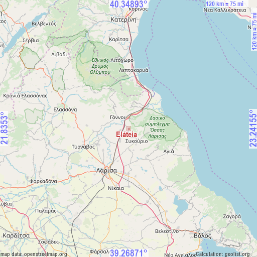
Eláteia GPS coordinates[2]
39° 48' 39.384" North, 22° 32' 18.312" East
| Map corner | latitude | longitude |
|---|---|---|
| Upper-left | 40.34893°, | 21.8353° |
| Center: | 39.81094°, | 22.53842° |
| Lower-right: | 39.26871°, | 23.24155° |
| Map W x H: | 120.1×120.1 km | = 74.6×74.6mi |
| max Lat: | 41.72048° ⇑35.3% North |
| Eláteia: | 39.81094° |
| min Lat: | ⇓64.7% South 34.8346° |
| min Long | Eláteia | max Long |
| 19.40494° | 22.53842° | 29.59361° |
| W 40.7%⇐ | ⇒59.3% E |
Elevation
Elevation of Eláteia is 116 m = 381 ft, and this is 52.9 m = 174 ft below average elevation for this country.
| Max E: |
1439 m = 4721 ft | 40.3% |
| Avg. | 168.9 m = 554 ft | |
| Eláteia | 116 m = 381 ft | |
Min E: |
0 m = 0 ft | 59.7% |
See also: Greece elevation on elevation.city.
Geographical zone
Eláteia is located in North temperate zone (between Tropic of Cancer and the Arctic Circle). Distance of this Northern Tropic circle is 1820.6 km =1131.3 mi to South.| Distance of | km | miles | from Eláteia |
|---|---|---|---|
| North Pole | 5580.5 | 3467.6 | to North |
| Arctic Circle | 2974.6 | 1848.3 | to North |
| Tropic Cancer | 1820.6 | 1131.3 | to South |
| Equator | 4426.6 | 2750.6 | to South |


Nearby cities:
15 places around Eláteia: (largest is in red/bold)
• Aigáni
17 km =10.6 mi,  21°
21°
• Ampelóna
16.5 km =10.3 mi,  243°
243°
• Argyropoúli
19.8 km =12.3 mi,  274°
274°
• Dasochóri
16.7 km =10.4 mi,  217°
217°
• Fálanna
15.7 km =9.8 mi,  229°
229°
• Giánnouli
20.1 km =12.5 mi, 217°
• Gónnoi
7.7 km =4.8 mi,  316°
316°
• Makrychóri
4.9 km =3 mi,  255°
255°
• Omólio
12.9 km =8 mi,  43°
43°
• Pournári
5.1 km =3.2 mi,  140°
140°
• Pyrgetós
12.9 km =8 mi, 21°
• Rapsáni
10.2 km =6.3 mi,  4°
4°
• Stómio
17.7 km =11 mi,  69°
69°
• Sykoúrio
6.7 km =4.2 mi,  148°
148°
• Óssa
8 km =5 mi, 154°
Sources, notices
• [Note1] Compared only with cities in Greece existing in our database
• [Src1] Map data: © OpenStreetMap contributors (CC-BY-SA)
• [Src2] Other city data from geonames.org with taken over terms of usage.
• [Src3] Geographical zone / Annual Mean Temperature by Robert A. Rohde @ Wikipedia
