Argyropoúli geodata
Argyropoúli (Thessaly) is a populated place; located in Greece in Europe/Athens (GMT+3) time zone. With population of 1,782 people, there are 574 cities with bigger population in this country. Compared to other cities in Greece, 64.8% of cities are located further ↓South; 65% of cities are located further →East and 61% of cities have lower elevation than Argyropoúli. Note1


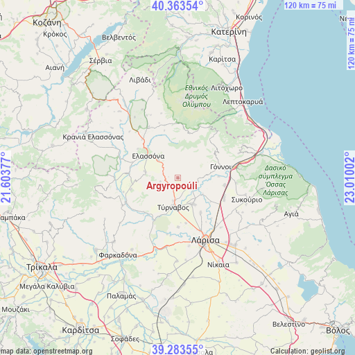
Argyropoúli GPS coordinates[2]
39° 49' 32.412" North, 22° 18' 24.804" East
| Map corner | latitude | longitude |
|---|---|---|
| Upper-left | 40.36354°, | 21.60377° |
| Center: | 39.82567°, | 22.30689° |
| Lower-right: | 39.28355°, | 23.01002° |
| Map W x H: | 120.1×120.1 km | = 74.6×74.6mi |
| max Lat: | 41.72048° ⇑35.2% North |
| Argyropoúli: | 39.82567° |
| min Lat: | ⇓64.8% South 34.8346° |
| min Long | Argyropoúli | max Long |
| 19.40494° | 22.30689° | 29.59361° |
| W 35%⇐ | ⇒65% E |
Elevation
Elevation of Argyropoúli is 121 m = 397 ft, and this is 47.9 m = 157 ft below average elevation for this country.
| Max E: |
1439 m = 4721 ft | 39% |
| Avg. | 168.9 m = 554 ft | |
| Argyropoúli | 121 m = 397 ft | |
Min E: |
0 m = 0 ft | 61% |
See also: Greece elevation on elevation.city.
Geographical zone
Argyropoúli is located in North temperate zone (between Tropic of Cancer and the Arctic Circle). Distance of this Northern Tropic circle is 1822.3 km =1132.3 mi to South.| Distance of | km | miles | from Argyropoúli |
|---|---|---|---|
| North Pole | 5578.9 | 3466.6 | to North |
| Arctic Circle | 2973 | 1847.3 | to North |
| Tropic Cancer | 1822.3 | 1132.3 | to South |
| Equator | 4428.2 | 2751.6 | to South |


Nearby cities:
15 places around Argyropoúli: (largest is in red/bold)
• Ampelóna
10.3 km =6.4 mi,  150°
150°
• Dasochóri
17.6 km =10.9 mi, 147°
• Elassóna
12.7 km =7.9 mi,  307°
307°
• Eláteia
19.8 km =12.3 mi,  94°
94°
• Evangelismós
17.4 km =10.8 mi,  275°
275°
• Fálanna
14.1 km =8.8 mi, 146°
• Giánnouli
19.2 km =11.9 mi,  156°
156°
• Gónnoi
15 km =9.3 mi,  74°
74°
• Kalývia
22.7 km =14.1 mi,  345°
345°
• Lárisa
23 km =14.3 mi, 155°
• Makrychóri
15.3 km =9.5 mi,  100°
100°
• Rapsáni
22.3 km =13.9 mi, 67°
• Tsarítsani
9.2 km =5.7 mi, 312°
• Týrnavos
9.9 km =6.2 mi,  188°
188°
• Vlachogiánni
20.8 km =12.9 mi,  243°
243°
Sources, notices
• [Note1] Compared only with cities in Greece existing in our database
• [Src1] Map data: © OpenStreetMap contributors (CC-BY-SA)
• [Src2] Other city data from geonames.org with taken over terms of usage.
• [Src3] Geographical zone / Annual Mean Temperature by Robert A. Rohde @ Wikipedia
