Loutráki geodata
Loutráki (Peloponnese) is a seat of a third-order administrative division; located in Greece in Europe/Athens (GMT+2) time zone. With population of 11,564 people, there are 128 cities with bigger population in this country. Compared to other cities in Greece, 74.6% of cities are located further ↑North; 54% of cities are located further ←West and 86.6% of cities have higher elevation than Loutráki. Note1
Administrative division(s):
- Level 1: Peloponnese
- Level 2: Nomós Korinthías
- Level 3: Dimos Loutraki-Agioi Theodoroi


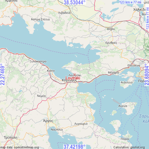
Loutráki GPS coordinates[2]
37° 58' 41.88" North, 22° 58' 40.116" East
| Map corner | latitude | longitude |
|---|---|---|
| Upper-left | 38.53044°, | 22.27469° |
| Center: | 37.9783°, | 22.97781° |
| Lower-right: | 37.42198°, | 23.68094° |
| Map W x H: | 123.2×123.2 km | = 76.6×76.6mi |
| max Lat: | 41.72048° ⇑74.6% North |
| Loutráki: | 37.9783° |
| min Lat: | ⇓25.4% South 34.8346° |
| min Long | Loutráki | max Long |
| 19.40494° | 22.97781° | 29.59361° |
| W 54%⇐ | ⇒46% E |
Elevation
Elevation of Loutráki is 11 m = 36 ft, and this is 157.9 m = 518 ft below average elevation for this country.
| Max E: |
1439 m = 4721 ft | 86.6% |
| Avg. | 168.9 m = 554 ft | |
| Loutráki | 11 m = 36 ft | |
Min E: |
0 m = 0 ft | 13.4% |
See also: Greece elevation on elevation.city.
Geographical zone
Loutráki is located in North temperate zone (between Tropic of Cancer and the Arctic Circle). Distance of this Northern Tropic circle is 1616.9 km =1004.7 mi to South.| Distance of | km | miles | from Loutráki |
|---|---|---|---|
| North Pole | 5784.3 | 3594.2 | to North |
| Arctic Circle | 3178.4 | 1975 | to North |
| Tropic Cancer | 1616.9 | 1004.7 | to South |
| Equator | 4222.8 | 2623.9 | to South |


Nearby cities:
15 places around Loutráki: (largest is in red/bold)
• Archaío Limáni
9.1 km =5.7 mi,  234°
234°
• Arkhaía Kórinthos
11.3 km =7 mi, 227°
• Examília
10 km =6.2 mi,  205°
205°
• Isthmía
7.6 km =4.7 mi,  161°
161°
• Kyrás Vrýsi
7.3 km =4.5 mi,  174°
174°
• Káto Examília
8.5 km =5.3 mi,  202°
202°
• Káto Ássos
13.4 km =8.3 mi,  255°
255°
• Kórinthos
4.8 km =3 mi, 208°
• Loutrá Oraías Elénis
12.7 km =7.9 mi, 172°
• Lékhaio
12.3 km =7.6 mi,  245°
245°
• Perachóra
6.3 km =3.9 mi,  336°
336°
• Periyiáli
12.8 km =8 mi, 250°
• Solomós
13.7 km =8.5 mi, 214°
• Xilokériza
11.1 km =6.9 mi, 196°
• Ássos
14.3 km =8.9 mi, 252°
Sources, notices
• [Note1] Compared only with cities in Greece existing in our database
• [Src1] Map data: © OpenStreetMap contributors (CC-BY-SA)
• [Src2] Other city data from geonames.org with taken over terms of usage.
• [Src3] Geographical zone / Annual Mean Temperature by Robert A. Rohde @ Wikipedia
