Kýthnos geodata
Kýthnos (South Aegean) is a seat of a third-order administrative division; located in Greece in Europe/Athens (GMT+3) time zone. In our database, there are 1823 cities with bigger population. Compared to other cities in Greece, 86.9% of cities are located further ↑North; 83.1% of cities are located further ←West and 69.2% of cities have lower elevation than Kýthnos. Note1


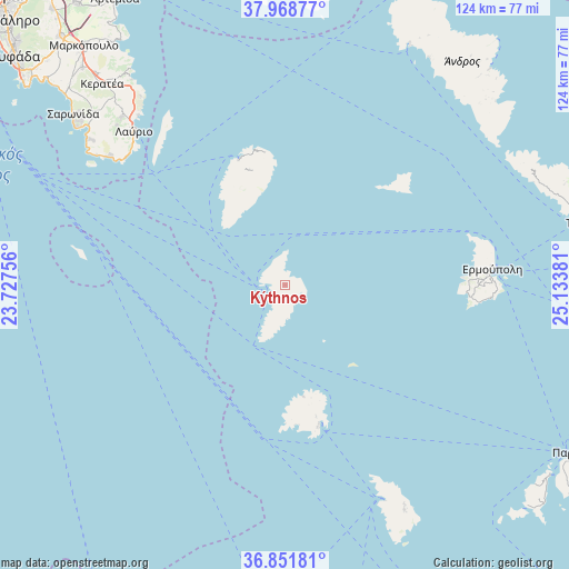
Kýthnos GPS coordinates[2]
37° 24' 44.532" North, 24° 25' 50.448" East
| Map corner | latitude | longitude |
|---|---|---|
| Upper-left | 37.96877°, | 23.72756° |
| Center: | 37.41237°, | 24.43068° |
| Lower-right: | 36.85181°, | 25.13381° |
| Map W x H: | 124.2×124.2 km | = 77.2×77.2mi |
| max Lat: | 41.72048° ⇑86.9% North |
| Kýthnos: | 37.41237° |
| min Lat: | ⇓13.1% South 34.8346° |
| min Long | Kýthnos | max Long |
| 19.40494° | 24.43068° | 29.59361° |
| W 83.1%⇐ | ⇒16.9% E |
Elevation
Elevation of Kýthnos is 159 m = 522 ft, and this is 9.9 m = 32 ft below average elevation for this country.
| Max E: |
1439 m = 4721 ft | 30.8% |
| Avg. | 168.9 m = 554 ft | |
| Kýthnos | 159 m = 522 ft | |
Min E: |
0 m = 0 ft | 69.2% |
See also: Greece elevation on elevation.city.
Geographical zone
Kýthnos is located in North temperate zone (between Tropic of Cancer and the Arctic Circle). Distance of this Northern Tropic circle is 1553.9 km =965.5 mi to South.| Distance of | km | miles | from Kýthnos |
|---|---|---|---|
| North Pole | 5847.2 | 3633.3 | to North |
| Arctic Circle | 3241.3 | 2014 | to North |
| Tropic Cancer | 1553.9 | 965.5 | to South |
| Equator | 4159.9 | 2584.8 | to South |


Nearby cities:
15 places around Kýthnos: (largest is in red/bold)
• Anávyssos
55.9 km =34.7 mi,  309°
309°
• Apollonía
55.3 km =34.4 mi,  151°
151°
• Artemón
54.5 km =33.9 mi, 151°
• Ergatikés Katoikíes Attikís
48.5 km =30.1 mi, 314°
• Ermoúpolis
45.4 km =28.2 mi,  85°
85°
• Kéa
25.6 km =15.9 mi,  343°
343°
• Livádion
30.5 km =19 mi,  165°
165°
• Lávrio
47.1 km =29.3 mi,  315°
315°
• Palaiá Fókaia
54.6 km =33.9 mi, 308°
• Pláka
53 km =32.9 mi, 317°
• Sérifos
29.5 km =18.3 mi, 166°
• Thymári
53.2 km =33.1 mi, 306°
• Vári
45.8 km =28.5 mi, 91°
• Ágios Konstantínos
50.7 km =31.5 mi, 313°
• Áno Sýros
44.8 km =27.8 mi,  84°
84°
Sources, notices
• [Note1] Compared only with cities in Greece existing in our database
• [Src1] Map data: © OpenStreetMap contributors (CC-BY-SA)
• [Src2] Other city data from geonames.org with taken over terms of usage.
• [Src3] Geographical zone / Annual Mean Temperature by Robert A. Rohde @ Wikipedia
