Kypséli geodata
Kypséli (Attica) is a populated place; located in Greece in Europe/Athens (GMT+3) time zone. With population of 2,124 people, there are 486 cities with bigger population in this country. Compared to other cities in Greece, 81.2% of cities are located further ↑North; 63.7% of cities are located further ←West and 57.7% of cities have higher elevation than Kypséli. Note1


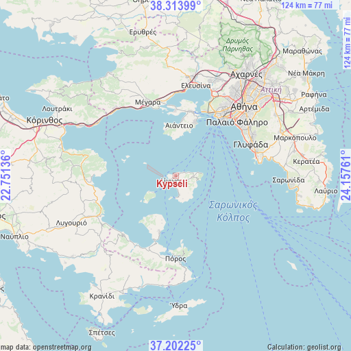
Kypséli GPS coordinates[2]
37° 45' 36.756" North, 23° 27' 16.128" East
| Map corner | latitude | longitude |
|---|---|---|
| Upper-left | 38.31399°, | 22.75136° |
| Center: | 37.76021°, | 23.45448° |
| Lower-right: | 37.20225°, | 24.15761° |
| Map W x H: | 123.6×123.6 km | = 76.8×76.8mi |
| max Lat: | 41.72048° ⇑81.2% North |
| Kypséli: | 37.76021° |
| min Lat: | ⇓18.8% South 34.8346° |
| min Long | Kypséli | max Long |
| 19.40494° | 23.45448° | 29.59361° |
| W 63.7%⇐ | ⇒36.3% E |
Elevation
Elevation of Kypséli is 57 m = 187 ft, and this is 111.9 m = 367 ft below average elevation for this country.
| Max E: |
1439 m = 4721 ft | 57.7% |
| Avg. | 168.9 m = 554 ft | |
| Kypséli | 57 m = 187 ft | |
Min E: |
0 m = 0 ft | 42.3% |
See also: Greece elevation on elevation.city.
Geographical zone
Kypséli is located in North temperate zone (between Tropic of Cancer and the Arctic Circle). Distance of this Northern Tropic circle is 1592.6 km =989.6 mi to South.| Distance of | km | miles | from Kypséli |
|---|---|---|---|
| North Pole | 5808.5 | 3609.2 | to North |
| Arctic Circle | 3202.6 | 1990 | to North |
| Tropic Cancer | 1592.6 | 989.6 | to South |
| Equator | 4198.5 | 2608.8 | to South |


Nearby cities:
15 places around Kypséli: (largest is in red/bold)
• Aegina
2.8 km =1.7 mi,  237°
237°
• Aiánteio
17.9 km =11.1 mi,  1°
1°
• Ampelákia
22.1 km =13.7 mi,  16°
16°
• Drapetsóna
25.8 km =16 mi,  35°
35°
• Lákka Kalogírou
26.7 km =16.6 mi,  346°
346°
• Megalochóri
11 km =6.8 mi, 239°
• Mesagrós
5.5 km =3.4 mi,  94°
94°
• Méthana
20.7 km =12.9 mi,  195°
195°
• Piraeus
26.3 km =16.3 mi, 39°
• Páchi
25.3 km =15.7 mi,  341°
341°
• Pérama
25.3 km =15.7 mi, 24°
• Pérdhika
7.6 km =4.7 mi,  180°
180°
• Salamína
23 km =14.3 mi,  9°
9°
• Selínia
20.4 km =12.7 mi, 19°
• Vathý
2.3 km =1.4 mi,  78°
78°
Sources, notices
• [Note1] Compared only with cities in Greece existing in our database
• [Src1] Map data: © OpenStreetMap contributors (CC-BY-SA)
• [Src2] Other city data from geonames.org with taken over terms of usage.
• [Src3] Geographical zone / Annual Mean Temperature by Robert A. Rohde @ Wikipedia
