Keratsíni geodata
Keratsíni (Attica) is a seat of a third-order administrative division; located in Greece in Europe/Athens (GMT+3) time zone. With population of 77,077 people, there are 15 cities with bigger population in this country. Compared to other cities in Greece, 75.5% of cities are located further ↑North; 67.2% of cities are located further ←West and 64.6% of cities have higher elevation than Keratsíni. Note1
Administrative division(s):
- Level 1: Attica
- Level 2: Nomós Piraiós
- Level 3: Dimos Keratsini-Drapetsona


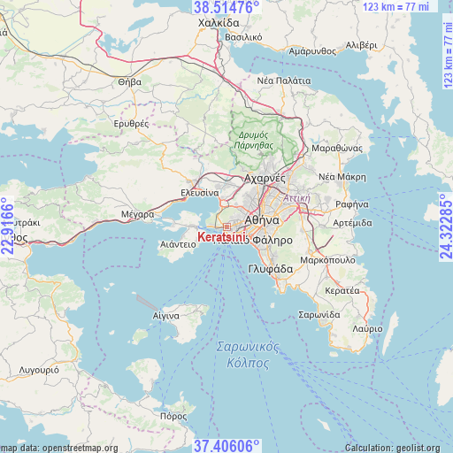
Keratsíni GPS coordinates[2]
37° 57' 45" North, 23° 37' 10.992" East
| Map corner | latitude | longitude |
|---|---|---|
| Upper-left | 38.51476°, | 22.9166° |
| Center: | 37.9625°, | 23.61972° |
| Lower-right: | 37.40606°, | 24.32285° |
| Map W x H: | 123.3×123.3 km | = 76.6×76.6mi |
| max Lat: | 41.72048° ⇑75.5% North |
| Keratsíni: | 37.9625° |
| min Lat: | ⇓24.5% South 34.8346° |
| min Long | Keratsíni | max Long |
| 19.40494° | 23.61972° | 29.59361° |
| W 67.2%⇐ | ⇒32.8% E |
Elevation
Elevation of Keratsíni is 40 m = 131 ft, and this is 128.9 m = 423 ft below average elevation for this country.
| Max E: |
1439 m = 4721 ft | 64.6% |
| Avg. | 168.9 m = 554 ft | |
| Keratsíni | 40 m = 131 ft | |
Min E: |
0 m = 0 ft | 35.4% |
See also: Keratsíni elevation on elevation.city.
Geographical zone
Keratsíni is located in North temperate zone (between Tropic of Cancer and the Arctic Circle). Distance of this Northern Tropic circle is 1615.1 km =1003.6 mi to South.| Distance of | km | miles | from Keratsíni |
|---|---|---|---|
| North Pole | 5786 | 3595.3 | to North |
| Arctic Circle | 3180.1 | 1976 | to North |
| Tropic Cancer | 1615.1 | 1003.6 | to South |
| Equator | 4221 | 2622.8 | to South |


Nearby cities:
15 places around Keratsíni: (largest is in red/bold)
• Agios Ioannis Rentis
4 km =2.5 mi,  86°
86°
• Agía Varvára
4.6 km =2.9 mi,  49°
49°
• Aigáleo
6 km =3.7 mi,  67°
67°
• Ampelákia
8.1 km =5 mi,  260°
260°
• Chaïdári
6.8 km =4.2 mi,  36°
36°
• Drapetsóna
1.4 km =0.9 mi,  168°
168°
• Kallithéa
7.2 km =4.5 mi,  101°
101°
• Korydallós
3.4 km =2.1 mi, 44°
• Moskháton
5.4 km =3.4 mi,  107°
107°
• Níkaia
2.7 km =1.7 mi,  80°
80°
• Palaió Fáliro
8.1 km =5 mi,  118°
118°
• Piraeus
3.3 km =2.1 mi,  134°
134°
• Pérama
4.2 km =2.6 mi,  277°
277°
• Skarmagkás
5.6 km =3.5 mi,  344°
344°
• Távros
6.3 km =3.9 mi, 81°
Sources, notices
• [Note1] Compared only with cities in Greece existing in our database
• [Src1] Map data: © OpenStreetMap contributors (CC-BY-SA)
• [Src2] Other city data from geonames.org with taken over terms of usage.
• [Src3] Geographical zone / Annual Mean Temperature by Robert A. Rohde @ Wikipedia
