Palioúri geodata
Palioúri (Thessaly) is a populated place; located in Greece in Europe/Athens (GMT+3) time zone. With population of 523 people, there are 1759 cities with bigger population in this country. Compared to other cities in Greece, 50.2% of cities are located further ↑North; 72.6% of cities are located further →East and 76.4% of cities have lower elevation than Palioúri. Note1


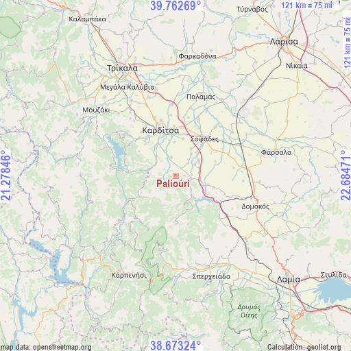
Palioúri GPS coordinates[2]
39° 13' 12.288" North, 21° 58' 53.688" East
| Map corner | latitude | longitude |
|---|---|---|
| Upper-left | 39.76269°, | 21.27846° |
| Center: | 39.22008°, | 21.98158° |
| Lower-right: | 38.67324°, | 22.68471° |
| Map W x H: | 121.1×121.1 km | = 75.2×75.2mi |
| max Lat: | 41.72048° ⇑50.2% North |
| Palioúri: | 39.22008° |
| min Lat: | ⇓49.8% South 34.8346° |
| min Long | Palioúri | max Long |
| 19.40494° | 21.98158° | 29.59361° |
| W 27.4%⇐ | ⇒72.6% E |
Elevation
Elevation of Palioúri is 225 m = 738 ft, and this is 56.1 m = 184 ft above average elevation for this country.
| Max E: |
1439 m = 4721 ft | 23.6% |
| Palioúri | 225 m 738 ft | |
| Avg. | 168.9 m = 554 ft | |
Min E: |
0 m = 0 ft | 76.4% |
See also: Greece elevation on elevation.city.
Geographical zone
Palioúri is located in North temperate zone (between Tropic of Cancer and the Arctic Circle). Distance of this Northern Tropic circle is 1754.9 km =1090.4 mi to South.| Distance of | km | miles | from Palioúri |
|---|---|---|---|
| North Pole | 5646.2 | 3508.4 | to North |
| Arctic Circle | 3040.3 | 1889.2 | to North |
| Tropic Cancer | 1754.9 | 1090.4 | to South |
| Equator | 4360.9 | 2709.7 | to South |


Nearby cities:
15 places around Palioúri: (largest is in red/bold)
• Anávra
10.2 km =6.3 mi,  109°
109°
• Georgikó
16.1 km =10 mi,  320°
320°
• Kallifóni
6.6 km =4.1 mi,  344°
344°
• Kallíthiro
9.5 km =5.9 mi, 315°
• Kardítsa
16.9 km =10.5 mi, 342°
• Karpochóri
13.1 km =8.1 mi,  11°
11°
• Krýa Vrýsi
14.8 km =9.2 mi, 321°
• Mavrika
14.1 km =8.8 mi,  345°
345°
• Pródromos
17.3 km =10.7 mi,  358°
358°
• Roússo
12.2 km =7.6 mi,  326°
326°
• Sofádes
16.2 km =10.1 mi,  38°
38°
• Stavrós
15.8 km =9.8 mi, 357°
• Xinonéri
15.1 km =9.4 mi, 316°
• Zaḯmi
9.6 km =6 mi, 337°
• Ágios Geórgios
15.2 km =9.4 mi,  304°
304°
Sources, notices
• [Note1] Compared only with cities in Greece existing in our database
• [Src1] Map data: © OpenStreetMap contributors (CC-BY-SA)
• [Src2] Other city data from geonames.org with taken over terms of usage.
• [Src3] Geographical zone / Annual Mean Temperature by Robert A. Rohde @ Wikipedia
