Kalampáka geodata
Kalampáka (Thessaly) is a seat of a third-order administrative division; located in Greece in Europe/Athens (GMT+3) time zone. With population of 8,138 people, there are 163 cities with bigger population in this country. Compared to other cities in Greece, 62.8% of cities are located further ↓South; 80.4% of cities are located further →East and 76% of cities have lower elevation than Kalampáka. Note1


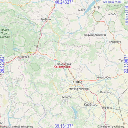
Kalampáka GPS coordinates[2]
39° 42' 15.984" North, 21° 37' 36.984" East
| Map corner | latitude | longitude |
|---|---|---|
| Upper-left | 40.24327°, | 20.92382° |
| Center: | 39.70444°, | 21.62694° |
| Lower-right: | 39.16137°, | 22.33007° |
| Map W x H: | 120.3×120.3 km | = 74.8×74.8mi |
| max Lat: | 41.72048° ⇑37.2% North |
| Kalampáka: | 39.70444° |
| min Lat: | ⇓62.8% South 34.8346° |
| min Long | Kalampáka | max Long |
| 19.40494° | 21.62694° | 29.59361° |
| W 19.6%⇐ | ⇒80.4% E |
Elevation
Elevation of Kalampáka is 221 m = 725 ft, and this is 52.1 m = 171 ft above average elevation for this country.
| Max E: |
1439 m = 4721 ft | 24% |
| Kalampáka | 221 m 725 ft | |
| Avg. | 168.9 m = 554 ft | |
Min E: |
0 m = 0 ft | 76% |
See also: Greece elevation on elevation.city.
Geographical zone
Kalampáka is located in North temperate zone (between Tropic of Cancer and the Arctic Circle). Distance of this Northern Tropic circle is 1808.8 km =1123.9 mi to South.| Distance of | km | miles | from Kalampáka |
|---|---|---|---|
| North Pole | 5592.3 | 3474.9 | to North |
| Arctic Circle | 2986.5 | 1855.7 | to North |
| Tropic Cancer | 1808.8 | 1123.9 | to South |
| Equator | 4414.7 | 2743.2 | to South |


Nearby cities:
15 places around Kalampáka: (largest is in red/bold)
• Ardáni
15.9 km =9.9 mi,  120°
120°
• Chrysomiliá
15.2 km =9.4 mi,  224°
224°
• Dialektó
12.4 km =7.7 mi,  170°
170°
• Diáva
4.1 km =2.5 mi,  251°
251°
• Kastráki
1.6 km =1 mi,  332°
332°
• Kefalóvryso
14.8 km =9.2 mi,  157°
157°
• Megárchis
10.5 km =6.5 mi, 172°
• Méga Kefalóvryso
15.5 km =9.6 mi,  145°
145°
• Plátanos
13.1 km =8.1 mi,  111°
111°
• Prínos
15.1 km =9.4 mi,  184°
184°
• Ráxa
14.6 km =9.1 mi,  135°
135°
• Rízoma
10.3 km =6.4 mi, 115°
• Theópetra
5.9 km =3.7 mi, 124°
• Vasilikí
9.8 km =6.1 mi, 137°
• Ávra
5.5 km =3.4 mi,  81°
81°
Sources, notices
• [Note1] Compared only with cities in Greece existing in our database
• [Src1] Map data: © OpenStreetMap contributors (CC-BY-SA)
• [Src2] Other city data from geonames.org with taken over terms of usage.
• [Src3] Geographical zone / Annual Mean Temperature by Robert A. Rohde @ Wikipedia
