Vasilikí geodata
Vasilikí (Thessaly) is a populated place; located in Greece in Europe/Athens (GMT+3) time zone. With population of 1,388 people, there are 729 cities with bigger population in this country. Compared to other cities in Greece, 61.1% of cities are located further ↓South; 78.2% of cities are located further →East and 67.2% of cities have lower elevation than Vasilikí. Note1


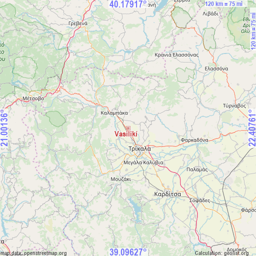
Vasilikí GPS coordinates[2]
39° 38' 23.424" North, 21° 42' 16.128" East
| Map corner | latitude | longitude |
|---|---|---|
| Upper-left | 40.17917°, | 21.00136° |
| Center: | 39.63984°, | 21.70448° |
| Lower-right: | 39.09627°, | 22.40761° |
| Map W x H: | 120.4×120.4 km | = 74.8×74.8mi |
| max Lat: | 41.72048° ⇑38.9% North |
| Vasilikí: | 39.63984° |
| min Lat: | ⇓61.1% South 34.8346° |
| min Long | Vasilikí | max Long |
| 19.40494° | 21.70448° | 29.59361° |
| W 21.8%⇐ | ⇒78.2% E |
Elevation
Elevation of Vasilikí is 148 m = 486 ft, and this is 20.9 m = 69 ft below average elevation for this country.
| Max E: |
1439 m = 4721 ft | 32.8% |
| Avg. | 168.9 m = 554 ft | |
| Vasilikí | 148 m = 486 ft | |
Min E: |
0 m = 0 ft | 67.2% |
See also: Greece elevation on elevation.city.
Geographical zone
Vasilikí is located in North temperate zone (between Tropic of Cancer and the Arctic Circle). Distance of this Northern Tropic circle is 1801.6 km =1119.5 mi to South.| Distance of | km | miles | from Vasilikí |
|---|---|---|---|
| North Pole | 5599.5 | 3479.4 | to North |
| Arctic Circle | 2993.6 | 1860.1 | to North |
| Tropic Cancer | 1801.6 | 1119.5 | to South |
| Equator | 4407.5 | 2738.7 | to South |


Nearby cities:
15 places around Vasilikí: (largest is in red/bold)
• Ardáni
7.1 km =4.4 mi,  97°
97°
• Dialektó
6.7 km =4.2 mi,  221°
221°
• Kalampáka
9.8 km =6.1 mi,  317°
317°
• Kefalóvryso
6.6 km =4.1 mi,  188°
188°
• Megárchis
6.2 km =3.9 mi,  238°
238°
• Méga Kefalóvryso
6 km =3.7 mi,  160°
160°
• Palaiópyrgos
10.3 km =6.4 mi,  109°
109°
• Plátanos
6 km =3.7 mi,  67°
67°
• Pyrgetós
10.4 km =6.5 mi, 158°
• Ráxa
4.9 km =3 mi,  131°
131°
• Rízoma
3.8 km =2.4 mi,  44°
44°
• Theópetra
4.2 km =2.6 mi,  334°
334°
• Tríkala
10.9 km =6.8 mi,  149°
149°
• Valtinó
10.8 km =6.7 mi,  200°
200°
• Ávra
8 km =5 mi,  351°
351°
Sources, notices
• [Note1] Compared only with cities in Greece existing in our database
• [Src1] Map data: © OpenStreetMap contributors (CC-BY-SA)
• [Src2] Other city data from geonames.org with taken over terms of usage.
• [Src3] Geographical zone / Annual Mean Temperature by Robert A. Rohde @ Wikipedia
