Kefalóvryso geodata
Kefalóvryso (Thessaly) is a populated place; located in Greece in Europe/Athens (GMT+3) time zone. With population of 959 people, there are 1062 cities with bigger population in this country. Compared to other cities in Greece, 58.7% of cities are located further ↓South; 78.7% of cities are located further →East and 62% of cities have lower elevation than Kefalóvryso. Note1


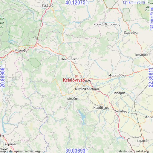
Kefalóvryso GPS coordinates[2]
39° 34' 51.456" North, 21° 41' 34.728" East
| Map corner | latitude | longitude |
|---|---|---|
| Upper-left | 40.12075°, | 20.98986° |
| Center: | 39.58096°, | 21.69298° |
| Lower-right: | 39.03693°, | 22.39611° |
| Map W x H: | 120.5×120.5 km | = 74.9×74.9mi |
| max Lat: | 41.72048° ⇑41.3% North |
| Kefalóvryso: | 39.58096° |
| min Lat: | ⇓58.7% South 34.8346° |
| min Long | Kefalóvryso | max Long |
| 19.40494° | 21.69298° | 29.59361° |
| W 21.3%⇐ | ⇒78.7% E |
Elevation
Elevation of Kefalóvryso is 126 m = 413 ft, and this is 42.9 m = 141 ft below average elevation for this country.
| Max E: |
1439 m = 4721 ft | 38% |
| Avg. | 168.9 m = 554 ft | |
| Kefalóvryso | 126 m = 413 ft | |
Min E: |
0 m = 0 ft | 62% |
See also: Greece elevation on elevation.city.
Geographical zone
Kefalóvryso is located in North temperate zone (between Tropic of Cancer and the Arctic Circle). Distance of this Northern Tropic circle is 1795.1 km =1115.4 mi to South.| Distance of | km | miles | from Kefalóvryso |
|---|---|---|---|
| North Pole | 5606.1 | 3483.5 | to North |
| Arctic Circle | 3000.2 | 1864.2 | to North |
| Tropic Cancer | 1795.1 | 1115.4 | to South |
| Equator | 4401 | 2734.7 | to South |


Nearby cities:
15 places around Kefalóvryso: (largest is in red/bold)
• Dendrochóri
5.7 km =3.5 mi,  236°
236°
• Dialektó
3.8 km =2.4 mi,  293°
293°
• Droseró
8.9 km =5.5 mi,  151°
151°
• Eleftherochóri
7.8 km =4.8 mi,  220°
220°
• Flamoúli
8.7 km =5.4 mi,  134°
134°
• Fíki
7.9 km =4.9 mi,  203°
203°
• Megárchis
5.4 km =3.4 mi,  307°
307°
• Méga Kefalóvryso
3.2 km =2 mi,  73°
73°
• Pigí
7.9 km =4.9 mi,  174°
174°
• Prínos
7.1 km =4.4 mi,  259°
259°
• Pyrgetós
5.7 km =3.5 mi,  123°
123°
• Ráxa
5.7 km =3.5 mi,  54°
54°
• Tríkala
7.1 km =4.4 mi,  114°
114°
• Valtinó
4.6 km =2.9 mi, 217°
• Vasilikí
6.6 km =4.1 mi,  8°
8°
Sources, notices
• [Note1] Compared only with cities in Greece existing in our database
• [Src1] Map data: © OpenStreetMap contributors (CC-BY-SA)
• [Src2] Other city data from geonames.org with taken over terms of usage.
• [Src3] Geographical zone / Annual Mean Temperature by Robert A. Rohde @ Wikipedia
