Ráxa geodata
Ráxa (Thessaly) is a populated place; located in Greece in Europe/Athens (GMT+3) time zone. With population of 673 people, there are 1456 cities with bigger population in this country. Compared to other cities in Greece, 60% of cities are located further ↓South; 77.5% of cities are located further →East and 62.7% of cities have lower elevation than Ráxa. Note1


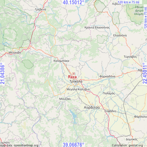
Ráxa GPS coordinates[2]
39° 36' 38.016" North, 21° 44' 49.128" East
| Map corner | latitude | longitude |
|---|---|---|
| Upper-left | 40.15012°, | 21.04386° |
| Center: | 39.61056°, | 21.74698° |
| Lower-right: | 39.06676°, | 22.45011° |
| Map W x H: | 120.5×120.5 km | = 74.9×74.9mi |
| max Lat: | 41.72048° ⇑40% North |
| Ráxa: | 39.61056° |
| min Lat: | ⇓60% South 34.8346° |
| min Long | Ráxa | max Long |
| 19.40494° | 21.74698° | 29.59361° |
| W 22.5%⇐ | ⇒77.5% E |
Elevation
Elevation of Ráxa is 129 m = 423 ft, and this is 39.9 m = 131 ft below average elevation for this country.
| Max E: |
1439 m = 4721 ft | 37.3% |
| Avg. | 168.9 m = 554 ft | |
| Ráxa | 129 m = 423 ft | |
Min E: |
0 m = 0 ft | 62.7% |
See also: Greece elevation on elevation.city.
Geographical zone
Ráxa is located in North temperate zone (between Tropic of Cancer and the Arctic Circle). Distance of this Northern Tropic circle is 1798.4 km =1117.5 mi to South.| Distance of | km | miles | from Ráxa |
|---|---|---|---|
| North Pole | 5602.8 | 3481.4 | to North |
| Arctic Circle | 2996.9 | 1862.2 | to North |
| Tropic Cancer | 1798.4 | 1117.5 | to South |
| Equator | 4404.3 | 2736.7 | to South |


Nearby cities:
15 places around Ráxa: (largest is in red/bold)
• Ardáni
4.1 km =2.5 mi,  55°
55°
• Dialektó
8.3 km =5.2 mi,  257°
257°
• Flamoúli
9.5 km =5.9 mi,  170°
170°
• Kefalóvryso
5.7 km =3.5 mi,  234°
234°
• Megárchis
8.9 km =5.5 mi,  270°
270°
• Méga Kefalóvryso
2.9 km =1.8 mi,  213°
213°
• Palaiópyrgos
6 km =3.7 mi,  92°
92°
• Plátanos
5.9 km =3.7 mi,  18°
18°
• Pyrgetós
6.4 km =4 mi,  178°
178°
• Rizarió
9.2 km =5.7 mi,  149°
149°
• Rízoma
6.1 km =3.8 mi,  350°
350°
• Theópetra
8.9 km =5.5 mi,  322°
322°
• Tríkala
6.5 km =4 mi,  163°
163°
• Vasilikí
4.9 km =3 mi,  311°
311°
• Zileftí
6.7 km =4.2 mi,  113°
113°
Sources, notices
• [Note1] Compared only with cities in Greece existing in our database
• [Src1] Map data: © OpenStreetMap contributors (CC-BY-SA)
• [Src2] Other city data from geonames.org with taken over terms of usage.
• [Src3] Geographical zone / Annual Mean Temperature by Robert A. Rohde @ Wikipedia
