Koropí geodata
Koropí (Attica) is a seat of a third-order administrative division; located in Greece in Europe/Athens (GMT+3) time zone. With population of 19,164 people, there are 95 cities with bigger population in this country. Compared to other cities in Greece, 77.9% of cities are located further ↑North; 75.4% of cities are located further ←West and 62.9% of cities have lower elevation than Koropí. Note1
Administrative division(s):
- Level 1: Attica
- Level 2: Nomarchía Anatolikís Attikís
- Level 3: Dimos Kropia


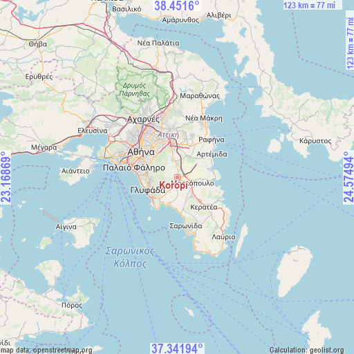
Koropí GPS coordinates[2]
37° 53' 55.896" North, 23° 52' 18.516" East
| Map corner | latitude | longitude |
|---|---|---|
| Upper-left | 38.4516°, | 23.16869° |
| Center: | 37.89886°, | 23.87181° |
| Lower-right: | 37.34194°, | 24.57494° |
| Map W x H: | 123.4×123.4 km | = 76.7×76.7mi |
| max Lat: | 41.72048° ⇑77.9% North |
| Koropí: | 37.89886° |
| min Lat: | ⇓22.1% South 34.8346° |
| min Long | Koropí | max Long |
| 19.40494° | 23.87181° | 29.59361° |
| W 75.4%⇐ | ⇒24.6% E |
Elevation
Elevation of Koropí is 130 m = 427 ft, and this is 38.9 m = 128 ft below average elevation for this country.
| Max E: |
1439 m = 4721 ft | 37.1% |
| Avg. | 168.9 m = 554 ft | |
| Koropí | 130 m = 427 ft | |
Min E: |
0 m = 0 ft | 62.9% |
See also: Greece elevation on elevation.city.
Geographical zone
Koropí is located in North temperate zone (between Tropic of Cancer and the Arctic Circle). Distance of this Northern Tropic circle is 1608 km =999.2 mi to South.| Distance of | km | miles | from Koropí |
|---|---|---|---|
| North Pole | 5793.1 | 3599.7 | to North |
| Arctic Circle | 3187.2 | 1980.4 | to North |
| Tropic Cancer | 1608 | 999.2 | to South |
| Equator | 4214 | 2618.5 | to South |


Nearby cities:
15 places around Koropí: (largest is in red/bold)
• Agios Dimítrios Kropiás
10.4 km =6.5 mi,  186°
186°
• Agía Marína
9.1 km =5.7 mi,  195°
195°
• Argithéa
8.6 km =5.3 mi,  8°
8°
• Argyroúpoli
10.7 km =6.6 mi,  274°
274°
• Christoúpoli
9.7 km =6 mi,  24°
24°
• Ilioúpoli
9.8 km =6.1 mi,  291°
291°
• Kalývia Thorikoú
8.1 km =5 mi,  144°
144°
• Karellás
4 km =2.5 mi,  351°
351°
• Kítsi
5.9 km =3.7 mi,  207°
207°
• Leondárion
9.9 km =6.2 mi, 351°
• Markópoulo
5.7 km =3.5 mi,  107°
107°
• Paianía
6.5 km =4 mi, 346°
• Spáta
7.9 km =4.9 mi,  28°
28°
• Voúla
10.5 km =6.5 mi,  233°
233°
• Vári
9.5 km =5.9 mi,  219°
219°
Sources, notices
• [Note1] Compared only with cities in Greece existing in our database
• [Src1] Map data: © OpenStreetMap contributors (CC-BY-SA)
• [Src2] Other city data from geonames.org with taken over terms of usage.
• [Src3] Geographical zone / Annual Mean Temperature by Robert A. Rohde @ Wikipedia
