Delvináki geodata
Delvináki (Epirus) is a populated place; located in Greece in Europe/Athens (GMT+3) time zone. With population of 772 people, there are 1303 cities with bigger population in this country. Compared to other cities in Greece, 65.9% of cities are located further ↓South; 96.5% of cities are located further →East and 95.1% of cities have lower elevation than Delvináki. Note1


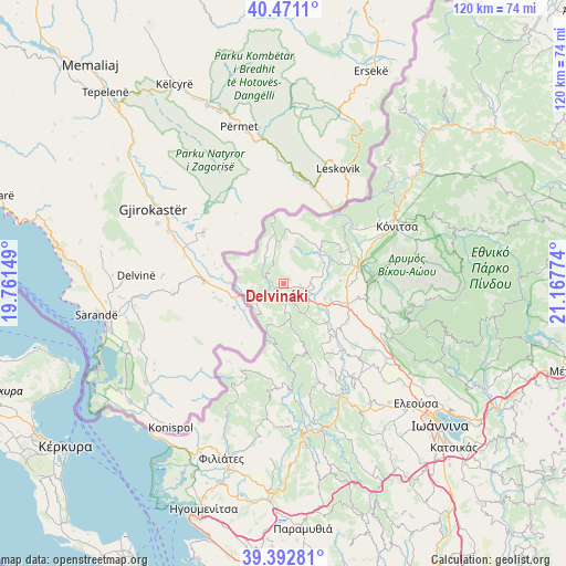
Delvináki GPS coordinates[2]
39° 56' 2.688" North, 20° 27' 52.596" East
| Map corner | latitude | longitude |
|---|---|---|
| Upper-left | 40.4711°, | 19.76149° |
| Center: | 39.93408°, | 20.46461° |
| Lower-right: | 39.39281°, | 21.16774° |
| Map W x H: | 119.9×119.9 km | = 74.5×74.5mi |
| max Lat: | 41.72048° ⇑34.1% North |
| Delvináki: | 39.93408° |
| min Lat: | ⇓65.9% South 34.8346° |
| min Long | Delvináki | max Long |
| 19.40494° | 20.46461° | 29.59361° |
| W 3.5%⇐ | ⇒96.5% E |
Elevation
Elevation of Delvináki is 671 m = 2201 ft, and this is 502.1 m = 1647 ft above average elevation for this country.
| Max E: |
1439 m = 4721 ft | 4.9% |
| Delvináki | 671 m 2201 ft | |
| Avg. | 168.9 m = 554 ft | |
Min E: |
0 m = 0 ft | 95.1% |
See also: Greece elevation on elevation.city.
Geographical zone
Delvináki is located in North temperate zone (between Tropic of Cancer and the Arctic Circle). Distance of this Northern Tropic circle is 1834.3 km =1139.8 mi to South.| Distance of | km | miles | from Delvináki |
|---|---|---|---|
| North Pole | 5566.8 | 3459 | to North |
| Arctic Circle | 2960.9 | 1839.8 | to North |
| Tropic Cancer | 1834.3 | 1139.8 | to South |
| Equator | 4440.3 | 2759.1 | to South |


Nearby cities:
15 places around Delvináki: (largest is in red/bold)
• Asprángeloi
25.7 km =16 mi,  118°
118°
• Eksochí
41.1 km =25.5 mi,  131°
131°
• Eleoúsa
37.7 km =23.4 mi, 132°
• Filiátes
39.3 km =24.4 mi,  199°
199°
• Kalpáki
14.5 km =9 mi,  110°
110°
• Kardamítsia
41.6 km =25.8 mi, 133°
• Kefalóvryso
11.8 km =7.3 mi,  42°
42°
• Kónitsa
27.9 km =17.3 mi,  62°
62°
• Metamórfosi
28.4 km =17.6 mi, 124°
• Parakálamos
11.6 km =7.2 mi, 132°
• Rodotópi
33.6 km =20.9 mi,  138°
138°
• Vounoplagiá
38.5 km =23.9 mi, 134°
• Zoodóchos
37.2 km =23.1 mi, 136°
• Zítsa
25.5 km =15.8 mi, 141°
• Ágios Ioánnis
39.8 km =24.7 mi, 131°
Sources, notices
• [Note1] Compared only with cities in Greece existing in our database
• [Src1] Map data: © OpenStreetMap contributors (CC-BY-SA)
• [Src2] Other city data from geonames.org with taken over terms of usage.
• [Src3] Geographical zone / Annual Mean Temperature by Robert A. Rohde @ Wikipedia
