Kónitsa geodata
Kónitsa (Epirus) is a seat of a third-order administrative division; located in Greece in Europe/Athens (GMT+3) time zone. With population of 2,942 people, there are 356 cities with bigger population in this country. Compared to other cities in Greece, 67.2% of cities are located further ↓South; 94.5% of cities are located further →East and 95.6% of cities have lower elevation than Kónitsa. Note1


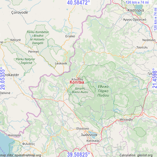
Kónitsa GPS coordinates[2]
40° 2' 54.996" North, 20° 45' 24.012" East
| Map corner | latitude | longitude |
|---|---|---|
| Upper-left | 40.58472°, | 20.05355° |
| Center: | 40.04861°, | 20.75667° |
| Lower-right: | 39.50825°, | 21.4598° |
| Map W x H: | 119.7×119.7 km | = 74.4×74.4mi |
| max Lat: | 41.72048° ⇑32.8% North |
| Kónitsa: | 40.04861° |
| min Lat: | ⇓67.2% South 34.8346° |
| min Long | Kónitsa | max Long |
| 19.40494° | 20.75667° | 29.59361° |
| W 5.5%⇐ | ⇒94.5% E |
Elevation
Elevation of Kónitsa is 691 m = 2267 ft, and this is 522.1 m = 1713 ft above average elevation for this country.
| Max E: |
1439 m = 4721 ft | 4.4% |
| Kónitsa | 691 m 2267 ft | |
| Avg. | 168.9 m = 554 ft | |
Min E: |
0 m = 0 ft | 95.6% |
See also: Greece elevation on elevation.city.
Geographical zone
Kónitsa is located in North temperate zone (between Tropic of Cancer and the Arctic Circle). Distance of this Northern Tropic circle is 1847.1 km =1147.7 mi to South.| Distance of | km | miles | from Kónitsa |
|---|---|---|---|
| North Pole | 5554.1 | 3451.2 | to North |
| Arctic Circle | 2948.2 | 1831.9 | to North |
| Tropic Cancer | 1847.1 | 1147.7 | to South |
| Equator | 4453 | 2767 | to South |


Nearby cities:
15 places around Kónitsa: (largest is in red/bold)
• Asprángeloi
25.2 km =15.7 mi,  185°
185°
• Delvináki
27.9 km =17.3 mi,  242°
242°
• Eksochí
40.5 km =25.2 mi,  172°
172°
• Eleoúsa
38.2 km =23.7 mi,  175°
175°
• Kalpáki
21.2 km =13.2 mi,  212°
212°
• Kefalóvryso
17.4 km =10.8 mi,  256°
256°
• Metamórfosi
28.7 km =17.8 mi, 182°
• Parakálamos
26.3 km =16.3 mi,  218°
218°
• Pérama
40.2 km =25 mi, 169°
• Rodotópi
37.9 km =23.5 mi, 183°
• Samarína
23.1 km =14.4 mi,  74°
74°
• Vounoplagiá
39.8 km =24.7 mi, 176°
• Zoodóchos
39.7 km =24.7 mi, 179°
• Zítsa
34 km =21.1 mi,  195°
195°
• Ágios Ioánnis
39.4 km =24.5 mi, 172°
Sources, notices
• [Note1] Compared only with cities in Greece existing in our database
• [Src1] Map data: © OpenStreetMap contributors (CC-BY-SA)
• [Src2] Other city data from geonames.org with taken over terms of usage.
• [Src3] Geographical zone / Annual Mean Temperature by Robert A. Rohde @ Wikipedia
