Parakálamos geodata
Parakálamos (Epirus) is a populated place; located in Greece in Europe/Athens (GMT+3) time zone. With population of 730 people, there are 1362 cities with bigger population in this country. Compared to other cities in Greece, 65.2% of cities are located further ↓South; 96.2% of cities are located further →East and 85.9% of cities have lower elevation than Parakálamos. Note1


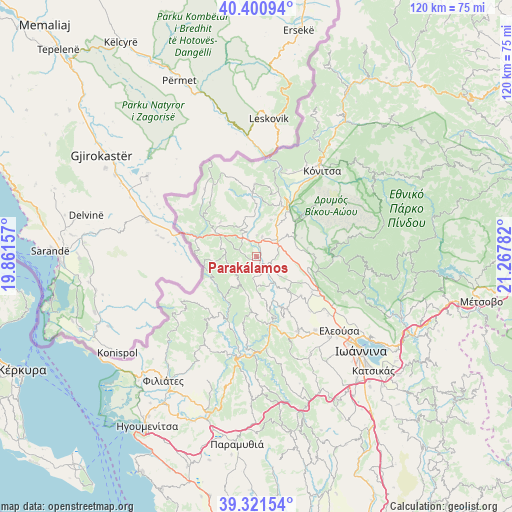
Parakálamos GPS coordinates[2]
39° 51' 48.096" North, 20° 33' 52.884" East
| Map corner | latitude | longitude |
|---|---|---|
| Upper-left | 40.40094°, | 19.86157° |
| Center: | 39.86336°, | 20.56469° |
| Lower-right: | 39.32154°, | 21.26782° |
| Map W x H: | 120×120 km | = 74.6×74.6mi |
| max Lat: | 41.72048° ⇑34.8% North |
| Parakálamos: | 39.86336° |
| min Lat: | ⇓65.2% South 34.8346° |
| min Long | Parakálamos | max Long |
| 19.40494° | 20.56469° | 29.59361° |
| W 3.8%⇐ | ⇒96.2% E |
Elevation
Elevation of Parakálamos is 399 m = 1309 ft, and this is 230.1 m = 755 ft above average elevation for this country.
| Max E: |
1439 m = 4721 ft | 14.1% |
| Parakálamos | 399 m 1309 ft | |
| Avg. | 168.9 m = 554 ft | |
Min E: |
0 m = 0 ft | 85.9% |
See also: Greece elevation on elevation.city.
Geographical zone
Parakálamos is located in North temperate zone (between Tropic of Cancer and the Arctic Circle). Distance of this Northern Tropic circle is 1826.5 km =1134.9 mi to South.| Distance of | km | miles | from Parakálamos |
|---|---|---|---|
| North Pole | 5574.7 | 3464 | to North |
| Arctic Circle | 2968.8 | 1844.7 | to North |
| Tropic Cancer | 1826.5 | 1134.9 | to South |
| Equator | 4432.4 | 2754.2 | to South |


Nearby cities:
15 places around Parakálamos: (largest is in red/bold)
• Asprángeloi
14.7 km =9.1 mi,  107°
107°
• Delvináki
11.6 km =7.2 mi,  312°
312°
• Eksochí
29.5 km =18.3 mi,  131°
131°
• Eleoúsa
26.1 km =16.2 mi, 131°
• Kalpáki
5.7 km =3.5 mi,  61°
61°
• Kardamítsia
30 km =18.6 mi, 133°
• Kefalóvryso
16.6 km =10.3 mi,  358°
358°
• Kónitsa
26.3 km =16.3 mi,  38°
38°
• Metamórfosi
17 km =10.6 mi,  118°
118°
• Mármara
30.4 km =18.9 mi,  139°
139°
• Rodotópi
22.1 km =13.7 mi, 141°
• Vounoplagiá
26.9 km =16.7 mi, 135°
• Zoodóchos
25.6 km =15.9 mi, 138°
• Zítsa
14.1 km =8.8 mi,  148°
148°
• Ágios Ioánnis
28.2 km =17.5 mi, 131°
Sources, notices
• [Note1] Compared only with cities in Greece existing in our database
• [Src1] Map data: © OpenStreetMap contributors (CC-BY-SA)
• [Src2] Other city data from geonames.org with taken over terms of usage.
• [Src3] Geographical zone / Annual Mean Temperature by Robert A. Rohde @ Wikipedia
