Atsikí geodata
Atsikí (North Aegean) is a populated place; located in Greece in Europe/Athens (GMT+3) time zone. With population of 886 people, there are 1147 cities with bigger population in this country. Compared to other cities in Greece, 66% of cities are located further ↓South; 88.7% of cities are located further ←West and 74.1% of cities have higher elevation than Atsikí. Note1


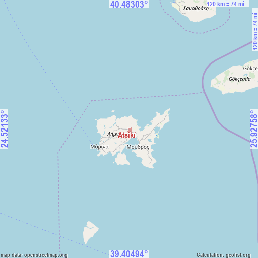
Atsikí GPS coordinates[2]
39° 56' 45.996" North, 25° 13' 28.02" East
| Map corner | latitude | longitude |
|---|---|---|
| Upper-left | 40.48303°, | 24.52133° |
| Center: | 39.94611°, | 25.22445° |
| Lower-right: | 39.40494°, | 25.92758° |
| Map W x H: | 119.9×119.9 km | = 74.5×74.5mi |
| max Lat: | 41.72048° ⇑34% North |
| Atsikí: | 39.94611° |
| min Lat: | ⇓66% South 34.8346° |
| min Long | Atsikí | max Long |
| 19.40494° | 25.22445° | 29.59361° |
| W 88.7%⇐ | ⇒11.3% E |
Elevation
Elevation of Atsikí is 25 m = 82 ft, and this is 143.9 m = 472 ft below average elevation for this country.
| Max E: |
1439 m = 4721 ft | 74.1% |
| Avg. | 168.9 m = 554 ft | |
| Atsikí | 25 m = 82 ft | |
Min E: |
0 m = 0 ft | 25.9% |
See also: Greece elevation on elevation.city.
Geographical zone
Atsikí is located in North temperate zone (between Tropic of Cancer and the Arctic Circle). Distance of this Northern Tropic circle is 1835.7 km =1140.7 mi to South.| Distance of | km | miles | from Atsikí |
|---|---|---|---|
| North Pole | 5565.5 | 3458.2 | to North |
| Arctic Circle | 2959.6 | 1839 | to North |
| Tropic Cancer | 1835.7 | 1140.7 | to South |
| Equator | 4441.6 | 2759.9 | to South |


Nearby cities:
15 places around Atsikí: (largest is in red/bold)
• Kamariótissa
62.5 km =38.8 mi,  19°
19°
• Karyes
90.2 km =56 mi,  292°
292°
• Limenária
93.6 km =58.2 mi,  324°
324°
• Míthymna
103.8 km =64.5 mi,  128°
128°
• Mýrina
15.8 km =9.8 mi,  239°
239°
• Panayía
96.8 km =60.1 mi,  334°
334°
• Potamiá
95.4 km =59.3 mi, 333°
• Potós
90.6 km =56.3 mi, 324°
• Prínos
104 km =64.6 mi, 328°
• Samothráki
63.8 km =39.6 mi, 23°
• Skála Kalliráchis
102.8 km =63.9 mi, 325°
• Theológos
91.2 km =56.7 mi, 330°
• Thásos
102.3 km =63.6 mi, 334°
• Ágios Efstrátios
49.5 km =30.8 mi,  203°
203°
• Ántissa
102.3 km =63.6 mi,  140°
140°
Sources, notices
• [Note1] Compared only with cities in Greece existing in our database
• [Src1] Map data: © OpenStreetMap contributors (CC-BY-SA)
• [Src2] Other city data from geonames.org with taken over terms of usage.
• [Src3] Geographical zone / Annual Mean Temperature by Robert A. Rohde @ Wikipedia
