Karyes geodata
Karyes (Mount Athos) is a seat of a first-order administrative division; located in Greece in Europe/Athens (GMT+3) time zone. With population of 237 people, there are 1816 cities with bigger population in this country. Compared to other cities in Greece, 69.2% of cities are located further ↓South; 81.5% of cities are located further ←West and 84.4% of cities have lower elevation than Karyes. Note1


Karyes GPS coordinates[2]
40° 15' 25.74" North, 24° 14' 41.928" East
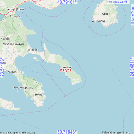
| Map corner | latitude | longitude |
|---|---|---|
| Upper-left | 40.79161°, | 23.54186° |
| Center: | 40.25715°, | 24.24498° |
| Lower-right: | 39.71843°, | 24.94811° |
| Map W x H: | 119.3×119.3 km | = 74.1×74.1mi |
| max Lat: | 41.72048° ⇑30.8% North |
| Karyes: | 40.25715° |
| min Lat: | ⇓69.2% South 34.8346° |
| min Long | Karyes | max Long |
| 19.40494° | 24.24498° | 29.59361° |
| W 81.5%⇐ | ⇒18.5% E |
Elevation
Elevation of Karyes is 364 m = 1194 ft, and this is 195.1 m = 640 ft above average elevation for this country.
| Max E: |
1439 m = 4721 ft | 15.6% |
| Karyes | 364 m 1194 ft | |
| Avg. | 168.9 m = 554 ft | |
Min E: |
0 m = 0 ft | 84.4% |
See also: Greece elevation on elevation.city.
Geographical zone
Karyes is located in North temperate zone (between Tropic of Cancer and the Arctic Circle). Distance of this Northern Tropic circle is 1870.3 km =1162.2 mi to South.| Distance of | km | miles | from Karyes |
|---|---|---|---|
| North Pole | 5530.9 | 3436.7 | to North |
| Arctic Circle | 2925 | 1817.5 | to North |
| Tropic Cancer | 1870.3 | 1162.2 | to South |
| Equator | 4476.2 | 2781.4 | to South |


Nearby cities:
15 places around Karyes: (largest is in red/bold)
• Ammoulianí
28.7 km =17.8 mi,  287°
287°
• Gomáti
41.1 km =25.5 mi, 292°
• Ierissós
35 km =21.7 mi,  296°
296°
• Limenária
49.8 km =30.9 mi,  34°
34°
• Metagkítsi
50.6 km =31.4 mi,  278°
278°
• Néa Róda
30.5 km =19 mi, 296°
• Néos Marmarás
43.1 km =26.8 mi,  245°
245°
• Níkiti
49.1 km =30.5 mi,  265°
265°
• Ouranoupolis
23.8 km =14.8 mi, 290°
• Potós
50 km =31.1 mi,  37°
37°
• Stratoníki
50.7 km =31.5 mi,  306°
306°
• Stratónion
45.6 km =28.3 mi, 308°
• Sykiá
35.5 km =22.1 mi,  226°
226°
• Sárti
29 km =18 mi, 231°
• Ágios Nikólaos
46.6 km =29 mi, 268°
Sources, notices
• [Note1] Compared only with cities in Greece existing in our database
• [Src1] Map data: © OpenStreetMap contributors (CC-BY-SA)
• [Src2] Other city data from geonames.org with taken over terms of usage.
• [Src3] Geographical zone / Annual Mean Temperature by Robert A. Rohde @ Wikipedia
