Samothráki geodata
Samothráki (East Macedonia and Thrace) is a seat of a third-order administrative division; located in Greece in Europe/Athens (GMT+3) time zone. With population of 719 people, there are 1384 cities with bigger population in this country. Compared to other cities in Greece, 73.5% of cities are located further ↓South; 91.1% of cities are located further ←West and 79.8% of cities have lower elevation than Samothráki. Note1
Administrative division(s):
- Level 1: East Macedonia and Thrace
- Level 2: Nomós Évrou
- Level 3: Dimos Samothrace


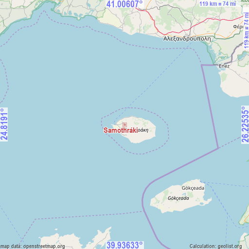
Samothráki GPS coordinates[2]
40° 28' 23.988" North, 25° 31' 19.992" East
| Map corner | latitude | longitude |
|---|---|---|
| Upper-left | 41.00607°, | 24.8191° |
| Center: | 40.47333°, | 25.52222° |
| Lower-right: | 39.93633°, | 26.22535° |
| Map W x H: | 118.9×118.9 km | = 73.9×73.9mi |
| max Lat: | 41.72048° ⇑26.5% North |
| Samothráki: | 40.47333° |
| min Lat: | ⇓73.5% South 34.8346° |
| min Long | Samothráki | max Long |
| 19.40494° | 25.52222° | 29.59361° |
| W 91.1%⇐ | ⇒8.9% E |
Elevation
Elevation of Samothráki is 275 m = 902 ft, and this is 106.1 m = 348 ft above average elevation for this country.
| Max E: |
1439 m = 4721 ft | 20.2% |
| Samothráki | 275 m 902 ft | |
| Avg. | 168.9 m = 554 ft | |
Min E: |
0 m = 0 ft | 79.8% |
See also: Greece elevation on elevation.city.
Geographical zone
Samothráki is located in North temperate zone (between Tropic of Cancer and the Arctic Circle). Distance of this Northern Tropic circle is 1894.3 km =1177.1 mi to South.| Distance of | km | miles | from Samothráki |
|---|---|---|---|
| North Pole | 5506.8 | 3421.8 | to North |
| Arctic Circle | 2901 | 1802.6 | to North |
| Tropic Cancer | 1894.3 | 1177.1 | to South |
| Equator | 4500.2 | 2796.3 | to South |


Nearby cities:
15 places around Samothráki: (largest is in red/bold)
• Alexandroupoli
51.4 km =31.9 mi,  35°
35°
• Arrianá
69.1 km =42.9 mi,  12°
12°
• Arísvi
66.6 km =41.4 mi,  4°
4°
• Atsikí
63.8 km =39.6 mi,  203°
203°
• Fillýra
72.1 km =44.8 mi, 7°
• Féres
72 km =44.7 mi,  49°
49°
• Kamariótissa
4 km =2.5 mi,  272°
272°
• Loutrós
63.4 km =39.4 mi, 44°
• Lýkeio
67.1 km =41.7 mi, 11°
• Nípsa
65.7 km =40.8 mi, 39°
• Pagoúria
64 km =39.8 mi,  344°
344°
• Sápes
63.4 km =39.4 mi, 13°
• Xylaganí
56.4 km =35 mi,  351°
351°
• Ántheia
59.3 km =36.8 mi, 41°
• Áratos
67.7 km =42.1 mi, 2°
Sources, notices
• [Note1] Compared only with cities in Greece existing in our database
• [Src1] Map data: © OpenStreetMap contributors (CC-BY-SA)
• [Src2] Other city data from geonames.org with taken over terms of usage.
• [Src3] Geographical zone / Annual Mean Temperature by Robert A. Rohde @ Wikipedia
