Kamariótissa geodata
Kamariótissa (East Macedonia and Thrace) is a populated place; located in Greece in Europe/Athens (GMT+3) time zone. With population of 1,022 people, there are 991 cities with bigger population in this country. Compared to other cities in Greece, 73.5% of cities are located further ↓South; 90.8% of cities are located further ←West and 83.9% of cities have higher elevation than Kamariótissa. Note1
Administrative division(s):
- Level 1: East Macedonia and Thrace
- Level 2: Nomós Évrou
- Level 3: Dimos Samothrace


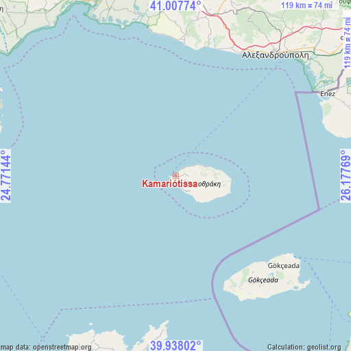
Kamariótissa GPS coordinates[2]
40° 28' 30.036" North, 25° 28' 28.416" East
| Map corner | latitude | longitude |
|---|---|---|
| Upper-left | 41.00774°, | 24.77144° |
| Center: | 40.47501°, | 25.47456° |
| Lower-right: | 39.93802°, | 26.17769° |
| Map W x H: | 118.9×118.9 km | = 73.9×73.9mi |
| max Lat: | 41.72048° ⇑26.5% North |
| Kamariótissa: | 40.47501° |
| min Lat: | ⇓73.5% South 34.8346° |
| min Long | Kamariótissa | max Long |
| 19.40494° | 25.47456° | 29.59361° |
| W 90.8%⇐ | ⇒9.2% E |
Elevation
Elevation of Kamariótissa is 14 m = 46 ft, and this is 154.9 m = 508 ft below average elevation for this country.
| Max E: |
1439 m = 4721 ft | 83.9% |
| Avg. | 168.9 m = 554 ft | |
| Kamariótissa | 14 m = 46 ft | |
Min E: |
0 m = 0 ft | 16.1% |
See also: Greece elevation on elevation.city.
Geographical zone
Kamariótissa is located in North temperate zone (between Tropic of Cancer and the Arctic Circle). Distance of this Northern Tropic circle is 1894.5 km =1177.2 mi to South.| Distance of | km | miles | from Kamariótissa |
|---|---|---|---|
| North Pole | 5506.7 | 3421.7 | to North |
| Arctic Circle | 2900.8 | 1802.5 | to North |
| Tropic Cancer | 1894.5 | 1177.2 | to South |
| Equator | 4500.4 | 2796.4 | to South |


Nearby cities:
15 places around Kamariótissa: (largest is in red/bold)
• Alexandroupoli
53.7 km =33.4 mi,  39°
39°
• Arísvi
66.9 km =41.6 mi,  8°
8°
• Atsikí
62.5 km =38.8 mi,  199°
199°
• Loutrós
66.1 km =41.1 mi,  46°
46°
• Lýkeio
67.9 km =42.2 mi,  15°
15°
• Nípsa
68.2 km =42.4 mi, 42°
• Pagoúria
62.9 km =39.1 mi,  347°
347°
• Panayía
69.1 km =42.9 mi,  294°
294°
• Potamiá
68.5 km =42.6 mi, 293°
• Samothráki
4 km =2.5 mi,  92°
92°
• Sápes
64.2 km =39.9 mi, 16°
• Theológos
69.2 km =43 mi, 287°
• Xylaganí
55.7 km =34.6 mi,  355°
355°
• Ántheia
61.9 km =38.5 mi, 44°
• Áratos
67.7 km =42.1 mi, 5°
Sources, notices
• [Note1] Compared only with cities in Greece existing in our database
• [Src1] Map data: © OpenStreetMap contributors (CC-BY-SA)
• [Src2] Other city data from geonames.org with taken over terms of usage.
• [Src3] Geographical zone / Annual Mean Temperature by Robert A. Rohde @ Wikipedia
