Astypálaia geodata
Astypálaia (South Aegean) is a seat of a third-order administrative division; located in Greece in Europe/Athens (GMT+3) time zone. With population of 1,129 people, there are 892 cities with bigger population in this country. Compared to other cities in Greece, 92.4% of cities are located further ↑North; 95.7% of cities are located further ←West and 61.4% of cities have higher elevation than Astypálaia. Note1


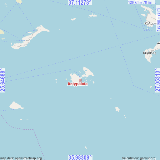
Astypálaia GPS coordinates[2]
36° 33' 0" North, 26° 21' 0" East
| Map corner | latitude | longitude |
|---|---|---|
| Upper-left | 37.11278°, | 25.64688° |
| Center: | 36.55°, | 26.35° |
| Lower-right: | 35.98309°, | 27.05313° |
| Map W x H: | 125.6×125.6 km | = 78×78mi |
| max Lat: | 41.72048° ⇑92.4% North |
| Astypálaia: | 36.55° |
| min Lat: | ⇓7.6% South 34.8346° |
| min Long | Astypálaia | max Long |
| 19.40494° | 26.35° | 29.59361° |
| W 95.7%⇐ | ⇒4.3% E |
Elevation
Elevation of Astypálaia is 46 m = 151 ft, and this is 122.9 m = 403 ft below average elevation for this country.
| Max E: |
1439 m = 4721 ft | 61.4% |
| Avg. | 168.9 m = 554 ft | |
| Astypálaia | 46 m = 151 ft | |
Min E: |
0 m = 0 ft | 38.6% |
See also: Greece elevation on elevation.city.
Geographical zone
Astypálaia is located in North temperate zone (between Tropic of Cancer and the Arctic Circle). Distance of this Northern Tropic circle is 1458.1 km =906 mi to South.| Distance of | km | miles | from Astypálaia |
|---|---|---|---|
| North Pole | 5943.1 | 3692.9 | to North |
| Arctic Circle | 3337.2 | 2073.6 | to North |
| Tropic Cancer | 1458.1 | 906 | to South |
| Equator | 4064 | 2525.3 | to South |


Nearby cities:
15 places around Astypálaia: (largest is in red/bold)
• Agía Marína
80.7 km =50.1 mi,  33°
33°
• Amorgós
51 km =31.7 mi,  307°
307°
• Antimácheia
72.6 km =45.1 mi,  66°
66°
• Anáfi
56.7 km =35.2 mi,  246°
246°
• Kamara
79.9 km =49.6 mi, 31°
• Kardámaina
75.3 km =46.8 mi, 69°
• Kálymnos
71.9 km =44.7 mi,  51°
51°
• Kéfalos
58.5 km =36.4 mi, 68°
• Lakkí
78.8 km =49 mi, 34°
• Linopótis
82.5 km =51.3 mi,  64°
64°
• Mandráki
70.3 km =43.7 mi,  84°
84°
• Mesariá
82.4 km =51.2 mi,  258°
258°
• Pylí
79.2 km =49.2 mi, 65°
• Pánormos
70.2 km =43.6 mi, 48°
• Xirókampos
77.5 km =48.2 mi,  36°
36°
Sources, notices
• [Note1] Compared only with cities in Greece existing in our database
• [Src1] Map data: © OpenStreetMap contributors (CC-BY-SA)
• [Src2] Other city data from geonames.org with taken over terms of usage.
• [Src3] Geographical zone / Annual Mean Temperature by Robert A. Rohde @ Wikipedia
