Amorgós geodata
Amorgós (South Aegean) is a seat of a third-order administrative division; located in Greece in Europe/Athens (GMT+3) time zone. With population of 397 people, there are 1808 cities with bigger population in this country. Compared to other cities in Greece, 91.1% of cities are located further ↑North; 92.6% of cities are located further ←West and 82% of cities have lower elevation than Amorgós. Note1


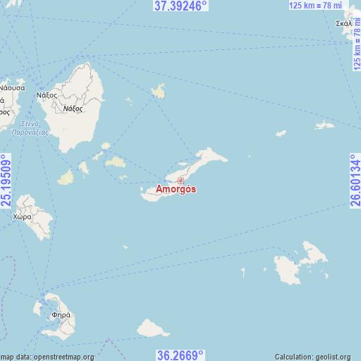
Amorgós GPS coordinates[2]
36° 49' 54.3" North, 25° 53' 53.556" East
| Map corner | latitude | longitude |
|---|---|---|
| Upper-left | 37.39246°, | 25.19509° |
| Center: | 36.83175°, | 25.89821° |
| Lower-right: | 36.2669°, | 26.60134° |
| Map W x H: | 125.2×125.1 km | = 77.8×77.7mi |
| max Lat: | 41.72048° ⇑91.1% North |
| Amorgós: | 36.83175° |
| min Lat: | ⇓8.9% South 34.8346° |
| min Long | Amorgós | max Long |
| 19.40494° | 25.89821° | 29.59361° |
| W 92.6%⇐ | ⇒7.4% E |
Elevation
Elevation of Amorgós is 316 m = 1037 ft, and this is 147.1 m = 483 ft above average elevation for this country.
| Max E: |
1439 m = 4721 ft | 18% |
| Amorgós | 316 m 1037 ft | |
| Avg. | 168.9 m = 554 ft | |
Min E: |
0 m = 0 ft | 82% |
See also: Greece elevation on elevation.city.
Geographical zone
Amorgós is located in North temperate zone (between Tropic of Cancer and the Arctic Circle). Distance of this Northern Tropic circle is 1489.4 km =925.5 mi to South.| Distance of | km | miles | from Amorgós |
|---|---|---|---|
| North Pole | 5911.8 | 3673.4 | to North |
| Arctic Circle | 3305.9 | 2054.2 | to North |
| Tropic Cancer | 1489.4 | 925.5 | to South |
| Equator | 4095.3 | 2544.7 | to South |


Nearby cities:
15 places around Amorgós: (largest is in red/bold)
• Anáfi
54.8 km =34.1 mi,  192°
192°
• Apérathos
42.9 km =26.7 mi,  308°
308°
• Astypálaia
51 km =31.7 mi,  127°
127°
• Emporeío
66.3 km =41.2 mi,  217°
217°
• Filótion
43.1 km =26.8 mi,  304°
304°
• Firá
61.8 km =38.4 mi, 222°
• Glinádo
51.5 km =32 mi, 301°
• Kóronos
45.3 km =28.1 mi, 314°
• Mesariá
62.7 km =39 mi, 219°
• Náousa
66.8 km =41.5 mi, 298°
• Náxos
55.5 km =34.5 mi, 303°
• Oía
62.1 km =38.6 mi,  228°
228°
• Vívlos
50.3 km =31.3 mi, 300°
• Ágios Arsénios
51.8 km =32.2 mi, 299°
• Íos
55.8 km =34.7 mi,  258°
258°
Sources, notices
• [Note1] Compared only with cities in Greece existing in our database
• [Src1] Map data: © OpenStreetMap contributors (CC-BY-SA)
• [Src2] Other city data from geonames.org with taken over terms of usage.
• [Src3] Geographical zone / Annual Mean Temperature by Robert A. Rohde @ Wikipedia
