Angelókastro geodata
Angelókastro (West Greece) is a populated place; located in Greece in Europe/Athens (GMT+3) time zone. With population of 1,220 people, there are 814 cities with bigger population in this country. Compared to other cities in Greece, 60.6% of cities are located further ↑North; 86.1% of cities are located further →East and 53.8% of cities have higher elevation than Angelókastro. Note1
Administrative division(s):
- Level 1: West Greece
- Level 2: Nomós Aitolías kai Akarnanías
- Level 3: Dimos Agrinio


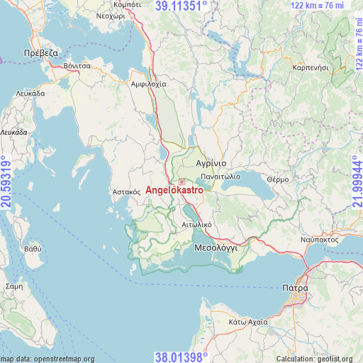
Angelókastro GPS coordinates[2]
38° 33' 57.06" North, 21° 17' 46.716" East
| Map corner | latitude | longitude |
|---|---|---|
| Upper-left | 39.11351°, | 20.59319° |
| Center: | 38.56585°, | 21.29631° |
| Lower-right: | 38.01398°, | 21.99944° |
| Map W x H: | 122.3×122.3 km | = 76×76mi |
| max Lat: | 41.72048° ⇑60.6% North |
| Angelókastro: | 38.56585° |
| min Lat: | ⇓39.4% South 34.8346° |
| min Long | Angelókastro | max Long |
| 19.40494° | 21.29631° | 29.59361° |
| W 13.9%⇐ | ⇒86.1% E |
Elevation
Elevation of Angelókastro is 68 m = 223 ft, and this is 100.9 m = 331 ft below average elevation for this country.
| Max E: |
1439 m = 4721 ft | 53.8% |
| Avg. | 168.9 m = 554 ft | |
| Angelókastro | 68 m = 223 ft | |
Min E: |
0 m = 0 ft | 46.2% |
See also: Greece elevation on elevation.city.
Geographical zone
Angelókastro is located in North temperate zone (between Tropic of Cancer and the Arctic Circle). Distance of this Northern Tropic circle is 1682.2 km =1045.3 mi to South.| Distance of | km | miles | from Angelókastro |
|---|---|---|---|
| North Pole | 5718.9 | 3553.6 | to North |
| Arctic Circle | 3113.1 | 1934.4 | to North |
| Tropic Cancer | 1682.2 | 1045.3 | to South |
| Equator | 4288.1 | 2664.5 | to South |


Nearby cities:
15 places around Angelókastro: (largest is in red/bold)
• Agrínio
11.5 km =7.1 mi,  57°
57°
• Dhokímion
9.1 km =5.7 mi,  54°
54°
• Gouriá
10.8 km =6.7 mi,  196°
196°
• Kalývia
5.7 km =3.5 mi,  356°
356°
• Megáli Khóra
11.2 km =7 mi,  36°
36°
• Neápolis
13.1 km =8.1 mi,  26°
26°
• Palaiománina
5.1 km =3.2 mi,  252°
252°
• Panaitólion
13.3 km =8.3 mi,  81°
81°
• Pendálofon
10 km =6.2 mi,  205°
205°
• Stamná
5.9 km =3.7 mi,  192°
192°
• Strátos
11.4 km =7.1 mi,  8°
8°
• Triandaíika
12.5 km =7.8 mi, 37°
• Zevgarákion
10.7 km =6.6 mi,  107°
107°
• Áyios Konstandínos
11.7 km =7.3 mi, 50°
• Ókhthia
10.3 km =6.4 mi,  354°
354°
Sources, notices
• [Note1] Compared only with cities in Greece existing in our database
• [Src1] Map data: © OpenStreetMap contributors (CC-BY-SA)
• [Src2] Other city data from geonames.org with taken over terms of usage.
• [Src3] Geographical zone / Annual Mean Temperature by Robert A. Rohde @ Wikipedia
