Gouriá geodata
Gouriá (West Greece) is a populated place; located in Greece in Europe/Athens (GMT+3) time zone. With population of 862 people, there are 1184 cities with bigger population in this country. Compared to other cities in Greece, 62.1% of cities are located further ↑North; 86.9% of cities are located further →East and 76.1% of cities have higher elevation than Gouriá. Note1
Administrative division(s):
- Level 1: West Greece
- Level 2: Nomós Aitolías kai Akarnanías
- Level 3: Dimos Missolonghi


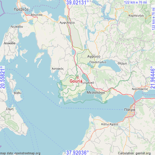
Gouriá GPS coordinates[2]
38° 28' 22.584" North, 21° 15' 40.788" East
| Map corner | latitude | longitude |
|---|---|---|
| Upper-left | 39.02131°, | 20.55821° |
| Center: | 38.47294°, | 21.26133° |
| Lower-right: | 37.92036°, | 21.96446° |
| Map W x H: | 122.4×122.4 km | = 76.1×76.1mi |
| max Lat: | 41.72048° ⇑62.1% North |
| Gouriá: | 38.47294° |
| min Lat: | ⇓37.9% South 34.8346° |
| min Long | Gouriá | max Long |
| 19.40494° | 21.26133° | 29.59361° |
| W 13.1%⇐ | ⇒86.9% E |
Elevation
Elevation of Gouriá is 22 m = 72 ft, and this is 146.9 m = 482 ft below average elevation for this country.
| Max E: |
1439 m = 4721 ft | 76.1% |
| Avg. | 168.9 m = 554 ft | |
| Gouriá | 22 m = 72 ft | |
Min E: |
0 m = 0 ft | 23.9% |
See also: Greece elevation on elevation.city.
Geographical zone
Gouriá is located in North temperate zone (between Tropic of Cancer and the Arctic Circle). Distance of this Northern Tropic circle is 1671.9 km =1038.9 mi to South.| Distance of | km | miles | from Gouriá |
|---|---|---|---|
| North Pole | 5729.3 | 3560 | to North |
| Arctic Circle | 3123.4 | 1940.8 | to North |
| Tropic Cancer | 1671.9 | 1038.9 | to South |
| Equator | 4277.8 | 2658.1 | to South |


Nearby cities:
15 places around Gouriá: (largest is in red/bold)
• Aitolikó
9 km =5.6 mi,  116°
116°
• Angelókastro
10.8 km =6.7 mi,  16°
16°
• Astakós
17.1 km =10.6 mi,  293°
293°
• Dhokímion
18.8 km =11.7 mi,  33°
33°
• Kalývia
16.3 km =10.1 mi,  9°
9°
• Karaïskákis
19.1 km =11.9 mi,  309°
309°
• Katochí
6.8 km =4.2 mi,  186°
186°
• Lesíni
3.4 km =2.1 mi,  227°
227°
• Mesolóngi
18.6 km =11.6 mi,  127°
127°
• Neochórion
7.3 km =4.5 mi,  170°
170°
• Palaiománina
9 km =5.6 mi,  348°
348°
• Pappadhátai
17.5 km =10.9 mi,  69°
69°
• Pendálofon
1.8 km =1.1 mi,  316°
316°
• Stamná
4.9 km =3 mi, 21°
• Zevgarákion
15.1 km =9.4 mi,  61°
61°
Sources, notices
• [Note1] Compared only with cities in Greece existing in our database
• [Src1] Map data: © OpenStreetMap contributors (CC-BY-SA)
• [Src2] Other city data from geonames.org with taken over terms of usage.
• [Src3] Geographical zone / Annual Mean Temperature by Robert A. Rohde @ Wikipedia
