Pendálofon geodata
Pendálofon (West Greece) is a populated place; located in Greece in Europe/Athens (GMT+3) time zone. With population of 889 people, there are 1144 cities with bigger population in this country. Compared to other cities in Greece, 61.7% of cities are located further ↑North; 87.1% of cities are located further →East and 80.3% of cities have higher elevation than Pendálofon. Note1
Administrative division(s):
- Level 1: West Greece
- Level 2: Nomós Aitolías kai Akarnanías
- Level 3: Dimos Missolonghi


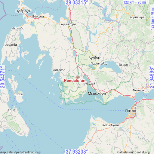
Pendálofon GPS coordinates[2]
38° 29' 5.532" North, 21° 14' 48.588" East
| Map corner | latitude | longitude |
|---|---|---|
| Upper-left | 39.03315°, | 20.54371° |
| Center: | 38.48487°, | 21.24683° |
| Lower-right: | 37.93238°, | 21.94996° |
| Map W x H: | 122.4×122.4 km | = 76.1×76.1mi |
| max Lat: | 41.72048° ⇑61.7% North |
| Pendálofon: | 38.48487° |
| min Lat: | ⇓38.3% South 34.8346° |
| min Long | Pendálofon | max Long |
| 19.40494° | 21.24683° | 29.59361° |
| W 12.9%⇐ | ⇒87.1% E |
Elevation
Elevation of Pendálofon is 17 m = 56 ft, and this is 151.9 m = 498 ft below average elevation for this country.
| Max E: |
1439 m = 4721 ft | 80.3% |
| Avg. | 168.9 m = 554 ft | |
| Pendálofon | 17 m = 56 ft | |
Min E: |
0 m = 0 ft | 19.7% |
See also: Greece elevation on elevation.city.
Geographical zone
Pendálofon is located in North temperate zone (between Tropic of Cancer and the Arctic Circle). Distance of this Northern Tropic circle is 1673.2 km =1039.7 mi to South.| Distance of | km | miles | from Pendálofon |
|---|---|---|---|
| North Pole | 5727.9 | 3559.2 | to North |
| Arctic Circle | 3122.1 | 1940 | to North |
| Tropic Cancer | 1673.2 | 1039.7 | to South |
| Equator | 4279.1 | 2658.9 | to South |


Nearby cities:
15 places around Pendálofon: (largest is in red/bold)
• Aitolikó
10.7 km =6.6 mi,  119°
119°
• Angelókastro
10 km =6.2 mi,  25°
25°
• Astakós
15.5 km =9.6 mi,  291°
291°
• Dhokímion
18.4 km =11.4 mi,  39°
39°
• Gouriá
1.8 km =1.1 mi,  136°
136°
• Kalývia
15.3 km =9.5 mi,  15°
15°
• Karaïskákis
17.2 km =10.7 mi,  308°
308°
• Katochí
8.1 km =5 mi,  176°
176°
• Lesíni
3.8 km =2.4 mi,  199°
199°
• Neochórion
8.8 km =5.5 mi,  163°
163°
• Palaiománina
7.5 km =4.7 mi,  355°
355°
• Pappadhátai
18.3 km =11.4 mi,  74°
74°
• Stamná
4.5 km =2.8 mi, 43°
• Vasilópoulo
18.2 km =11.3 mi, 311°
• Zevgarákion
15.6 km =9.7 mi, 68°
Sources, notices
• [Note1] Compared only with cities in Greece existing in our database
• [Src1] Map data: © OpenStreetMap contributors (CC-BY-SA)
• [Src2] Other city data from geonames.org with taken over terms of usage.
• [Src3] Geographical zone / Annual Mean Temperature by Robert A. Rohde @ Wikipedia
