Stamná geodata
Stamná (West Greece) is a populated place; located in Greece in Europe/Athens (GMT+3) time zone. With population of 921 people, there are 1104 cities with bigger population in this country. Compared to other cities in Greece, 61.5% of cities are located further ↑North; 86.5% of cities are located further →East and 61.7% of cities have lower elevation than Stamná. Note1
Administrative division(s):
- Level 1: West Greece
- Level 2: Nomós Aitolías kai Akarnanías
- Level 3: Dimos Missolonghi


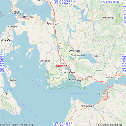
Stamná GPS coordinates[2]
38° 30' 51.084" North, 21° 16' 54.516" East
| Map corner | latitude | longitude |
|---|---|---|
| Upper-left | 39.06225°, | 20.57869° |
| Center: | 38.51419°, | 21.28181° |
| Lower-right: | 37.96193°, | 21.98494° |
| Map W x H: | 122.3×122.3 km | = 76×76mi |
| max Lat: | 41.72048° ⇑61.5% North |
| Stamná: | 38.51419° |
| min Lat: | ⇓38.5% South 34.8346° |
| min Long | Stamná | max Long |
| 19.40494° | 21.28181° | 29.59361° |
| W 13.5%⇐ | ⇒86.5% E |
Elevation
Elevation of Stamná is 125 m = 410 ft, and this is 43.9 m = 144 ft below average elevation for this country.
| Max E: |
1439 m = 4721 ft | 38.3% |
| Avg. | 168.9 m = 554 ft | |
| Stamná | 125 m = 410 ft | |
Min E: |
0 m = 0 ft | 61.7% |
See also: Greece elevation on elevation.city.
Geographical zone
Stamná is located in North temperate zone (between Tropic of Cancer and the Arctic Circle). Distance of this Northern Tropic circle is 1676.5 km =1041.7 mi to South.| Distance of | km | miles | from Stamná |
|---|---|---|---|
| North Pole | 5724.7 | 3557.2 | to North |
| Arctic Circle | 3118.8 | 1937.9 | to North |
| Tropic Cancer | 1676.5 | 1041.7 | to South |
| Equator | 4282.4 | 2661 | to South |


Nearby cities:
15 places around Stamná: (largest is in red/bold)
• Agrínio
16.2 km =10.1 mi,  42°
42°
• Aitolikó
10.6 km =6.6 mi,  143°
143°
• Angelókastro
5.9 km =3.7 mi,  12°
12°
• Dhokímion
14 km =8.7 mi, 37°
• Gouriá
4.9 km =3 mi,  201°
201°
• Kalývia
11.5 km =7.1 mi,  4°
4°
• Katochí
11.6 km =7.2 mi,  192°
192°
• Lesíni
8.1 km =5 mi,  212°
212°
• Neochórion
11.8 km =7.3 mi,  182°
182°
• Palaiománina
5.6 km =3.5 mi,  319°
319°
• Panaitólion
16.3 km =10.1 mi,  61°
61°
• Pappadhátai
14.7 km =9.1 mi,  83°
83°
• Pendálofon
4.5 km =2.8 mi,  223°
223°
• Zevgarákion
11.8 km =7.3 mi, 77°
• Ókhthia
16 km =9.9 mi, 1°
Sources, notices
• [Note1] Compared only with cities in Greece existing in our database
• [Src1] Map data: © OpenStreetMap contributors (CC-BY-SA)
• [Src2] Other city data from geonames.org with taken over terms of usage.
• [Src3] Geographical zone / Annual Mean Temperature by Robert A. Rohde @ Wikipedia
