Antikyra geodata
Antikyra (Central Greece) is a populated place; located in Greece in Europe/Athens (GMT+3) time zone. With population of 1,448 people, there are 690 cities with bigger population in this country. Compared to other cities in Greece, 64.2% of cities are located further ↑North; 56.4% of cities are located further →East and 62.6% of cities have higher elevation than Antikyra. Note1
Administrative division(s):
- Level 1: Central Greece
- Level 2: Nomós Voiotías
- Level 3: Dimos Distomo-Arachova-Antikyra


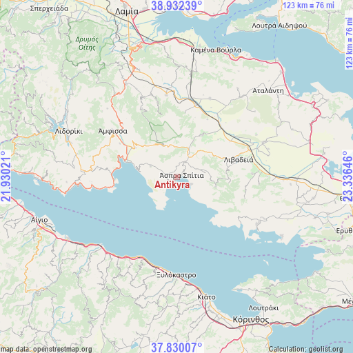
Antikyra GPS coordinates[2]
38° 22' 59.988" North, 22° 37' 59.988" East
| Map corner | latitude | longitude |
|---|---|---|
| Upper-left | 38.93239°, | 21.93021° |
| Center: | 38.38333°, | 22.63333° |
| Lower-right: | 37.83007°, | 23.33646° |
| Map W x H: | 122.6×122.6 km | = 76.2×76.2mi |
| max Lat: | 41.72048° ⇑64.2% North |
| Antikyra: | 38.38333° |
| min Lat: | ⇓35.8% South 34.8346° |
| min Long | Antikyra | max Long |
| 19.40494° | 22.63333° | 29.59361° |
| W 43.6%⇐ | ⇒56.4% E |
Elevation
Elevation of Antikyra is 44 m = 144 ft, and this is 124.9 m = 410 ft below average elevation for this country.
| Max E: |
1439 m = 4721 ft | 62.6% |
| Avg. | 168.9 m = 554 ft | |
| Antikyra | 44 m = 144 ft | |
Min E: |
0 m = 0 ft | 37.4% |
See also: Greece elevation on elevation.city.
Geographical zone
Antikyra is located in North temperate zone (between Tropic of Cancer and the Arctic Circle). Distance of this Northern Tropic circle is 1661.9 km =1032.7 mi to South.| Distance of | km | miles | from Antikyra |
|---|---|---|---|
| North Pole | 5739.2 | 3566.2 | to North |
| Arctic Circle | 3133.3 | 1946.9 | to North |
| Tropic Cancer | 1661.9 | 1032.7 | to South |
| Equator | 4267.8 | 2651.9 | to South |


Nearby cities:
15 places around Antikyra: (largest is in red/bold)
• Agía Triáda
24.2 km =15 mi,  97°
97°
• Aráchova
11.5 km =7.1 mi,  337°
337°
• Chairóneia
22.2 km =13.8 mi,  55°
55°
• Delphi
16.2 km =10.1 mi,  311°
311°
• Dístomo
5.9 km =3.7 mi,  30°
30°
• Galaxídhion
22.1 km =13.7 mi,  269°
269°
• Itéa
19 km =11.8 mi,  286°
286°
• Kyriáki
13.9 km =8.6 mi, 103°
• Káto Tithoréa
25.9 km =16.1 mi,  15°
15°
• Kírra
17.2 km =10.7 mi, 287°
• Livadeiá
22 km =13.7 mi,  74°
74°
• Steíri
7.4 km =4.6 mi, 67°
• Tithoréa
22.5 km =14 mi,  7°
7°
• Ágios Geórgios
26 km =16.2 mi,  87°
87°
• Ámfissa
27.5 km =17.1 mi, 305°
Sources, notices
• [Note1] Compared only with cities in Greece existing in our database
• [Src1] Map data: © OpenStreetMap contributors (CC-BY-SA)
• [Src2] Other city data from geonames.org with taken over terms of usage.
• [Src3] Geographical zone / Annual Mean Temperature by Robert A. Rohde @ Wikipedia
