Kyriáki geodata
Kyriáki (Central Greece) is a populated place; located in Greece in Europe/Athens (GMT+3) time zone. With population of 2,227 people, there are 460 cities with bigger population in this country. Compared to other cities in Greece, 64.7% of cities are located further ↑North; 52% of cities are located further →East and 96.8% of cities have lower elevation than Kyriáki. Note1


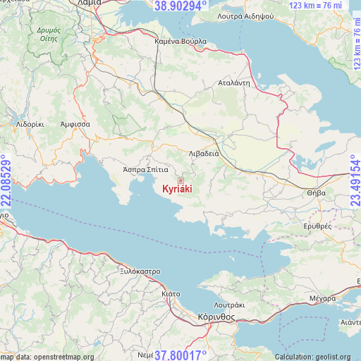
Kyriáki GPS coordinates[2]
38° 21' 13.14" North, 22° 47' 18.276" East
| Map corner | latitude | longitude |
|---|---|---|
| Upper-left | 38.90294°, | 22.08529° |
| Center: | 38.35365°, | 22.78841° |
| Lower-right: | 37.80017°, | 23.49154° |
| Map W x H: | 122.6×122.6 km | = 76.2×76.2mi |
| max Lat: | 41.72048° ⇑64.7% North |
| Kyriáki: | 38.35365° |
| min Lat: | ⇓35.3% South 34.8346° |
| min Long | Kyriáki | max Long |
| 19.40494° | 22.78841° | 29.59361° |
| W 48%⇐ | ⇒52% E |
Elevation
Elevation of Kyriáki is 762 m = 2500 ft, and this is 593.1 m = 1946 ft above average elevation for this country.
| Max E: |
1439 m = 4721 ft | 3.2% |
| Kyriáki | 762 m 2500 ft | |
| Avg. | 168.9 m = 554 ft | |
Min E: |
0 m = 0 ft | 96.8% |
See also: Greece elevation on elevation.city.
Geographical zone
Kyriáki is located in North temperate zone (between Tropic of Cancer and the Arctic Circle). Distance of this Northern Tropic circle is 1658.6 km =1030.6 mi to South.| Distance of | km | miles | from Kyriáki |
|---|---|---|---|
| North Pole | 5742.5 | 3568.2 | to North |
| Arctic Circle | 3136.6 | 1949 | to North |
| Tropic Cancer | 1658.6 | 1030.6 | to South |
| Equator | 4264.5 | 2649.8 | to South |


Nearby cities:
15 places around Kyriáki: (largest is in red/bold)
• Agía Triáda
10.5 km =6.5 mi,  89°
89°
• Alíartos
27.2 km =16.9 mi, 86°
• Antikyra
13.9 km =8.6 mi,  283°
283°
• Aráchova
22.7 km =14.1 mi,  308°
308°
• Chairóneia
16.5 km =10.3 mi,  17°
17°
• Delphi
29.2 km =18.1 mi,  298°
298°
• Domvraína
20.3 km =12.6 mi,  123°
123°
• Dístomo
13.5 km =8.4 mi, 308°
• Káto Tithoréa
29 km =18 mi,  346°
346°
• Livadeiá
12 km =7.5 mi,  39°
39°
• Orchomenós
22.7 km =14.1 mi,  47°
47°
• Steíri
9 km =5.6 mi, 312°
• Tithoréa
27.7 km =17.2 mi,  337°
337°
• Ágios Geórgios
13.3 km =8.3 mi,  70°
70°
• Éxarkhos
29.4 km =18.3 mi,  27°
27°
Sources, notices
• [Note1] Compared only with cities in Greece existing in our database
• [Src1] Map data: © OpenStreetMap contributors (CC-BY-SA)
• [Src2] Other city data from geonames.org with taken over terms of usage.
• [Src3] Geographical zone / Annual Mean Temperature by Robert A. Rohde @ Wikipedia
