Agía Triáda geodata
Agía Triáda (Central Greece) is a populated place; located in Greece in Europe/Athens (GMT+3) time zone. With population of 1,098 people, there are 920 cities with bigger population in this country. Compared to other cities in Greece, 64.7% of cities are located further ↑North; 51.9% of cities are located further ←West and 86% of cities have lower elevation than Agía Triáda. Note1


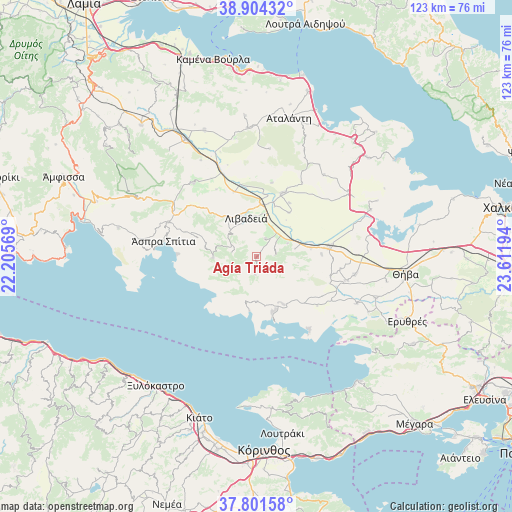
Agía Triáda GPS coordinates[2]
38° 21' 18.18" North, 22° 54' 31.716" East
| Map corner | latitude | longitude |
|---|---|---|
| Upper-left | 38.90432°, | 22.20569° |
| Center: | 38.35505°, | 22.90881° |
| Lower-right: | 37.80158°, | 23.61194° |
| Map W x H: | 122.6×122.6 km | = 76.2×76.2mi |
| max Lat: | 41.72048° ⇑64.7% North |
| Agía Triáda: | 38.35505° |
| min Lat: | ⇓35.3% South 34.8346° |
| min Long | Agía Triáda | max Long |
| 19.40494° | 22.90881° | 29.59361° |
| W 51.9%⇐ | ⇒48.1% E |
Elevation
Elevation of Agía Triáda is 402 m = 1319 ft, and this is 233.1 m = 765 ft above average elevation for this country.
| Max E: |
1439 m = 4721 ft | 14% |
| Agía Triáda | 402 m 1319 ft | |
| Avg. | 168.9 m = 554 ft | |
Min E: |
0 m = 0 ft | 86% |
See also: Greece elevation on elevation.city.
Geographical zone
Agía Triáda is located in North temperate zone (between Tropic of Cancer and the Arctic Circle). Distance of this Northern Tropic circle is 1658.8 km =1030.7 mi to South.| Distance of | km | miles | from Agía Triáda |
|---|---|---|---|
| North Pole | 5742.4 | 3568.2 | to North |
| Arctic Circle | 3136.5 | 1948.9 | to North |
| Tropic Cancer | 1658.8 | 1030.7 | to South |
| Equator | 4264.7 | 2650 | to South |


Nearby cities:
15 places around Agía Triáda: (largest is in red/bold)
• Akraifnía
29.4 km =18.3 mi,  67°
67°
• Alíartos
16.7 km =10.4 mi,  85°
85°
• Antikyra
24.2 km =15 mi,  277°
277°
• Chairóneia
16.6 km =10.3 mi,  340°
340°
• Domvraína
13 km =8.1 mi,  150°
150°
• Dístomo
22.6 km =14 mi,  291°
291°
• Kyriáki
10.5 km =6.5 mi,  269°
269°
• Kástron
26.8 km =16.7 mi,  54°
54°
• Livadeiá
9.4 km =5.8 mi, 342°
• Orchomenós
16.5 km =10.3 mi,  21°
21°
• Steíri
18.2 km =11.3 mi, 289°
• Thespiés
21.8 km =13.5 mi,  105°
105°
• Vágia
23.8 km =14.8 mi,  100°
100°
• Ágios Geórgios
4.7 km =2.9 mi,  25°
25°
• Éxarkhos
26.1 km =16.2 mi,  6°
6°
Sources, notices
• [Note1] Compared only with cities in Greece existing in our database
• [Src1] Map data: © OpenStreetMap contributors (CC-BY-SA)
• [Src2] Other city data from geonames.org with taken over terms of usage.
• [Src3] Geographical zone / Annual Mean Temperature by Robert A. Rohde @ Wikipedia
