Livadeiá geodata
Livadeiá (Central Greece) is a seat of a second-order administrative division; located in Greece in Europe/Athens (GMT+3) time zone. With population of 21,492 people, there are 89 cities with bigger population in this country. Compared to other cities in Greece, 62.9% of cities are located further ↑North; 51.1% of cities are located further ←West and 71% of cities have lower elevation than Livadeiá. Note1


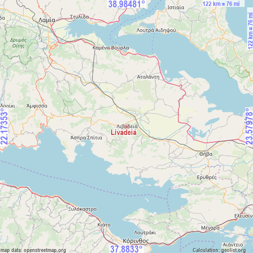
Livadeiá GPS coordinates[2]
38° 26' 10.176" North, 22° 52' 35.94" East
| Map corner | latitude | longitude |
|---|---|---|
| Upper-left | 38.98481°, | 22.17353° |
| Center: | 38.43616°, | 22.87665° |
| Lower-right: | 37.8833°, | 23.57978° |
| Map W x H: | 122.5×122.5 km | = 76.1×76.1mi |
| max Lat: | 41.72048° ⇑62.9% North |
| Livadeiá: | 38.43616° |
| min Lat: | ⇓37.1% South 34.8346° |
| min Long | Livadeiá | max Long |
| 19.40494° | 22.87665° | 29.59361° |
| W 51.1%⇐ | ⇒48.9% E |
Elevation
Elevation of Livadeiá is 174 m = 571 ft, and this is 5.1 m = 17 ft above average elevation for this country.
| Max E: |
1439 m = 4721 ft | 29% |
| Livadeiá | 174 m 571 ft | |
| Avg. | 168.9 m = 554 ft | |
Min E: |
0 m = 0 ft | 71% |
See also: Greece elevation on elevation.city.
Geographical zone
Livadeiá is located in North temperate zone (between Tropic of Cancer and the Arctic Circle). Distance of this Northern Tropic circle is 1667.8 km =1036.3 mi to South.| Distance of | km | miles | from Livadeiá |
|---|---|---|---|
| North Pole | 5733.4 | 3562.6 | to North |
| Arctic Circle | 3127.5 | 1943.3 | to North |
| Tropic Cancer | 1667.8 | 1036.3 | to South |
| Equator | 4273.7 | 2655.6 | to South |


Nearby cities:
15 places around Livadeiá: (largest is in red/bold)
• Agía Triáda
9.4 km =5.8 mi,  162°
162°
• Alíartos
20.9 km =13 mi,  111°
111°
• Antikyra
22 km =13.7 mi,  254°
254°
• Chairóneia
7.2 km =4.5 mi,  336°
336°
• Domvraína
22.3 km =13.9 mi, 155°
• Dístomo
18.3 km =11.4 mi,  267°
267°
• Eláteia
23.4 km =14.5 mi, 335°
• Kyriáki
12 km =7.5 mi,  219°
219°
• Káto Tithoréa
23.8 km =14.8 mi,  323°
323°
• Orchomenós
11 km =6.8 mi,  54°
54°
• Steíri
14.7 km =9.1 mi,  257°
257°
• Tithoréa
24.5 km =15.2 mi,  312°
312°
• Zéli
24.8 km =15.4 mi,  359°
359°
• Ágios Geórgios
6.8 km =4.2 mi,  134°
134°
• Éxarkhos
17.9 km =11.1 mi,  19°
19°
In other languages:
- In France: Livadiá
- In German: Livadia
- In Italian: Livadeia
- In Russian: Левадия
- In Chinese: 莱瓦贾
Sources, notices
• [Note1] Compared only with cities in Greece existing in our database
• [Src1] Map data: © OpenStreetMap contributors (CC-BY-SA)
• [Src2] Other city data from geonames.org with taken over terms of usage.
• [Src3] Geographical zone / Annual Mean Temperature by Robert A. Rohde @ Wikipedia
