Stavrós geodata
Stavrós (Central Macedonia) is a populated place; located in Greece in Europe/Athens (GMT+3) time zone. With population of 1,529 people, there are 651 cities with bigger population in this country. Compared to other cities in Greece, 77.2% of cities are located further ↓South; 64.9% of cities are located further →East and 87.7% of cities have higher elevation than Stavrós. Note1
Administrative division(s):
- Level 1: Central Macedonia
- Level 2: Nomós Imathías
- Level 3: Dimos Alexandreia


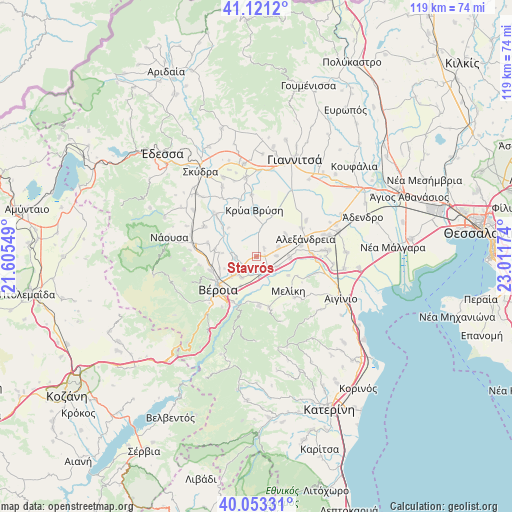
Stavrós GPS coordinates[2]
40° 35' 21.804" North, 22° 18' 30.996" East
| Map corner | latitude | longitude |
|---|---|---|
| Upper-left | 41.1212°, | 21.60549° |
| Center: | 40.58939°, | 22.30861° |
| Lower-right: | 40.05331°, | 23.01174° |
| Map W x H: | 118.7×118.7 km | = 73.8×73.8mi |
| max Lat: | 41.72048° ⇑22.8% North |
| Stavrós: | 40.58939° |
| min Lat: | ⇓77.2% South 34.8346° |
| min Long | Stavrós | max Long |
| 19.40494° | 22.30861° | 29.59361° |
| W 35.1%⇐ | ⇒64.9% E |
Elevation
Elevation of Stavrós is 10 m = 33 ft, and this is 158.9 m = 521 ft below average elevation for this country.
| Max E: |
1439 m = 4721 ft | 87.7% |
| Avg. | 168.9 m = 554 ft | |
| Stavrós | 10 m = 33 ft | |
Min E: |
0 m = 0 ft | 12.3% |
See also: Greece elevation on elevation.city.
Geographical zone
Stavrós is located in North temperate zone (between Tropic of Cancer and the Arctic Circle). Distance of this Northern Tropic circle is 1907.2 km =1185.1 mi to South.| Distance of | km | miles | from Stavrós |
|---|---|---|---|
| North Pole | 5493.9 | 3413.8 | to North |
| Arctic Circle | 2888.1 | 1794.6 | to North |
| Tropic Cancer | 1907.2 | 1185.1 | to South |
| Equator | 4513.1 | 2804.3 | to South |


Nearby cities:
15 places around Stavrós: (largest is in red/bold)
• Agía Marína
7.9 km =4.9 mi,  276°
276°
• Diavatós
6 km =3.7 mi,  216°
216°
• Episkopí
4.7 km =2.9 mi,  87°
87°
• Kampochóri
5.6 km =3.5 mi,  66°
66°
• Kavásila
2 km =1.2 mi,  83°
83°
• Kefalochóri
5.3 km =3.3 mi,  115°
115°
• Kouloúra
4.8 km =3 mi,  170°
170°
• Loutrós
7.7 km =4.8 mi, 90°
• Makrochóri
6.5 km =4 mi,  229°
229°
• Nisí
8.5 km =5.3 mi,  52°
52°
• Néa Lykógianni
6.2 km =3.9 mi,  252°
252°
• Néa Nikomídeia
5 km =3.1 mi,  266°
266°
• Palaió Skyllítsi
2.5 km =1.6 mi,  43°
43°
• Pródromos
8.6 km =5.3 mi, 119°
• Xechasméni
3.5 km =2.2 mi,  131°
131°
Sources, notices
• [Note1] Compared only with cities in Greece existing in our database
• [Src1] Map data: © OpenStreetMap contributors (CC-BY-SA)
• [Src2] Other city data from geonames.org with taken over terms of usage.
• [Src3] Geographical zone / Annual Mean Temperature by Robert A. Rohde @ Wikipedia
