Xechasméni geodata
Xechasméni (Central Macedonia) is a populated place; located in Greece in Europe/Athens (GMT+3) time zone. With population of 795 people, there are 1278 cities with bigger population in this country. Compared to other cities in Greece, 76.6% of cities are located further ↓South; 64.3% of cities are located further →East and 81.5% of cities have higher elevation than Xechasméni. Note1
Administrative division(s):
- Level 1: Central Macedonia
- Level 2: Nomós Imathías
- Level 3: Dimos Alexandreia


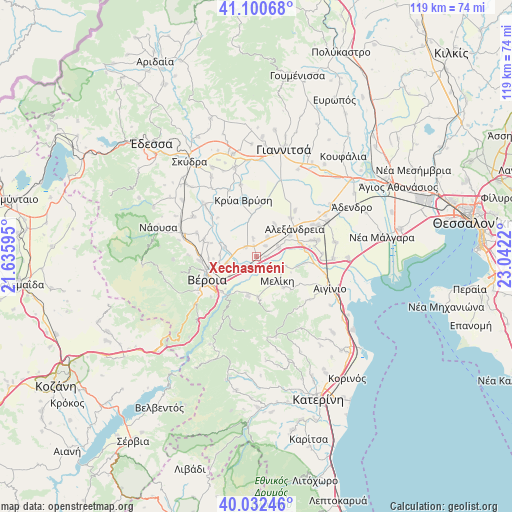
Xechasméni GPS coordinates[2]
40° 34' 7.32" North, 22° 20' 20.652" East
| Map corner | latitude | longitude |
|---|---|---|
| Upper-left | 41.10068°, | 21.63595° |
| Center: | 40.5687°, | 22.33907° |
| Lower-right: | 40.03246°, | 23.0422° |
| Map W x H: | 118.8×118.8 km | = 73.8×73.8mi |
| max Lat: | 41.72048° ⇑23.4% North |
| Xechasméni: | 40.5687° |
| min Lat: | ⇓76.6% South 34.8346° |
| min Long | Xechasméni | max Long |
| 19.40494° | 22.33907° | 29.59361° |
| W 35.7%⇐ | ⇒64.3% E |
Elevation
Elevation of Xechasméni is 16 m = 52 ft, and this is 152.9 m = 502 ft below average elevation for this country.
| Max E: |
1439 m = 4721 ft | 81.5% |
| Avg. | 168.9 m = 554 ft | |
| Xechasméni | 16 m = 52 ft | |
Min E: |
0 m = 0 ft | 18.5% |
See also: Greece elevation on elevation.city.
Geographical zone
Xechasméni is located in North temperate zone (between Tropic of Cancer and the Arctic Circle). Distance of this Northern Tropic circle is 1904.9 km =1183.6 mi to South.| Distance of | km | miles | from Xechasméni |
|---|---|---|---|
| North Pole | 5496.2 | 3415.2 | to North |
| Arctic Circle | 2890.4 | 1796 | to North |
| Tropic Cancer | 1904.9 | 1183.6 | to South |
| Equator | 4510.8 | 2802.9 | to South |


Nearby cities:
15 places around Xechasméni: (largest is in red/bold)
• Diavatós
6.6 km =4.1 mi,  247°
247°
• Episkopí
3.3 km =2.1 mi,  40°
40°
• Kampochóri
5.2 km =3.2 mi,  29°
29°
• Kavásila
2.6 km =1.6 mi,  346°
346°
• Kefalochóri
2.3 km =1.4 mi,  89°
89°
• Kouloúra
3 km =1.9 mi,  215°
215°
• Loutrós
5.6 km =3.5 mi,  66°
66°
• Makrochóri
7.8 km =4.8 mi,  255°
255°
• Melíki
7.5 km =4.7 mi,  140°
140°
• Néa Lykógianni
8.5 km =5.3 mi,  272°
272°
• Néa Nikomídeia
7.8 km =4.8 mi,  285°
285°
• Palaió Skyllítsi
4.2 km =2.6 mi, 348°
• Pródromos
5.3 km =3.3 mi,  112°
112°
• Stavrós
3.5 km =2.2 mi,  311°
311°
• Vrysáki
7.9 km =4.9 mi, 43°
Sources, notices
• [Note1] Compared only with cities in Greece existing in our database
• [Src1] Map data: © OpenStreetMap contributors (CC-BY-SA)
• [Src2] Other city data from geonames.org with taken over terms of usage.
• [Src3] Geographical zone / Annual Mean Temperature by Robert A. Rohde @ Wikipedia
