Sitochóri geodata
Sitochóri (Central Macedonia) is a populated place; located in Greece in Europe/Athens (GMT+3) time zone. With population of 531 people, there are 1737 cities with bigger population in this country. Compared to other cities in Greece, 88% of cities are located further ↓South; 67.2% of cities are located further ←West and 51.8% of cities have lower elevation than Sitochóri. Note1
Administrative division(s):
- Level 1: Central Macedonia
- Level 2: Nomós Serrón
- Level 3: Dimos Visaltia


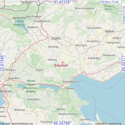
Sitochóri GPS coordinates[2]
40° 52' 54.192" North, 23° 37' 6.888" East
| Map corner | latitude | longitude |
|---|---|---|
| Upper-left | 41.41119°, | 22.91546° |
| Center: | 40.88172°, | 23.61858° |
| Lower-right: | 40.34798°, | 24.32171° |
| Map W x H: | 118.2×118.2 km | = 73.4×73.4mi |
| max Lat: | 41.72048° ⇑12% North |
| Sitochóri: | 40.88172° |
| min Lat: | ⇓88% South 34.8346° |
| min Long | Sitochóri | max Long |
| 19.40494° | 23.61858° | 29.59361° |
| W 67.2%⇐ | ⇒32.8% E |
Elevation
Elevation of Sitochóri is 88 m = 289 ft, and this is 80.9 m = 265 ft below average elevation for this country.
| Max E: |
1439 m = 4721 ft | 48.2% |
| Avg. | 168.9 m = 554 ft | |
| Sitochóri | 88 m = 289 ft | |
Min E: |
0 m = 0 ft | 51.8% |
See also: Greece elevation on elevation.city.
Geographical zone
Sitochóri is located in North temperate zone (between Tropic of Cancer and the Arctic Circle). Distance of this Northern Tropic circle is 1939.7 km =1205.3 mi to South.| Distance of | km | miles | from Sitochóri |
|---|---|---|---|
| North Pole | 5461.4 | 3393.6 | to North |
| Arctic Circle | 2855.6 | 1774.4 | to North |
| Tropic Cancer | 1939.7 | 1205.3 | to South |
| Equator | 4545.6 | 2824.5 | to South |


Nearby cities:
15 places around Sitochóri: (largest is in red/bold)
• Achinós
5.4 km =3.4 mi,  36°
36°
• Agía Paraskeví
15.5 km =9.6 mi,  298°
298°
• Anthí
11.7 km =7.3 mi,  306°
306°
• Aréthousa
15.5 km =9.6 mi,  189°
189°
• Efkarpía
13.1 km =8.1 mi,  99°
99°
• Flámpouro
7 km =4.3 mi,  321°
321°
• Mavrothálassa
11.2 km =7 mi,  82°
82°
• Nigríta
10.4 km =6.5 mi,  284°
284°
• Nikókleia
17 km =10.6 mi,  289°
289°
• Néos Skopós
15.8 km =9.8 mi,  357°
357°
• Paralímnio
12.3 km =7.6 mi,  20°
20°
• Psychikó
13.6 km =8.5 mi,  4°
4°
• Terpní
12.2 km =7.6 mi, 288°
• Valtotópi
12.6 km =7.8 mi,  351°
351°
• Ívira
6.9 km =4.3 mi, 77°
Sources, notices
• [Note1] Compared only with cities in Greece existing in our database
• [Src1] Map data: © OpenStreetMap contributors (CC-BY-SA)
• [Src2] Other city data from geonames.org with taken over terms of usage.
• [Src3] Geographical zone / Annual Mean Temperature by Robert A. Rohde @ Wikipedia
