Nigríta geodata
Nigríta (Central Macedonia) is a seat of a third-order administrative division; located in Greece in Europe/Athens (GMT+3) time zone. With population of 4,947 people, there are 240 cities with bigger population in this country. Compared to other cities in Greece, 88.6% of cities are located further ↓South; 64.6% of cities are located further ←West and 50.9% of cities have higher elevation than Nigríta. Note1
Administrative division(s):
- Level 1: Central Macedonia
- Level 2: Nomós Serrón
- Level 3: Dimos Visaltia


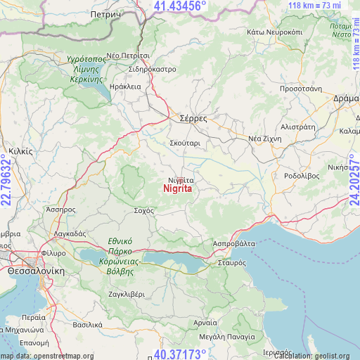
Nigríta GPS coordinates[2]
40° 54' 19.008" North, 23° 29' 57.984" East
| Map corner | latitude | longitude |
|---|---|---|
| Upper-left | 41.43456°, | 22.79632° |
| Center: | 40.90528°, | 23.49944° |
| Lower-right: | 40.37173°, | 24.20257° |
| Map W x H: | 118.2×118.2 km | = 73.4×73.4mi |
| max Lat: | 41.72048° ⇑11.4% North |
| Nigríta: | 40.90528° |
| min Lat: | ⇓88.6% South 34.8346° |
| min Long | Nigríta | max Long |
| 19.40494° | 23.49944° | 29.59361° |
| W 64.6%⇐ | ⇒35.4% E |
Elevation
Elevation of Nigríta is 78 m = 256 ft, and this is 90.9 m = 298 ft below average elevation for this country.
| Max E: |
1439 m = 4721 ft | 50.9% |
| Avg. | 168.9 m = 554 ft | |
| Nigríta | 78 m = 256 ft | |
Min E: |
0 m = 0 ft | 49.1% |
See also: Greece elevation on elevation.city.
Geographical zone
Nigríta is located in North temperate zone (between Tropic of Cancer and the Arctic Circle). Distance of this Northern Tropic circle is 1942.3 km =1206.9 mi to South.| Distance of | km | miles | from Nigríta |
|---|---|---|---|
| North Pole | 5458.8 | 3391.9 | to North |
| Arctic Circle | 2852.9 | 1772.7 | to North |
| Tropic Cancer | 1942.3 | 1206.9 | to South |
| Equator | 4548.2 | 2826.1 | to South |


Nearby cities:
15 places around Nigríta: (largest is in red/bold)
• Achinós
13.3 km =8.3 mi,  82°
82°
• Agía Paraskeví
6.1 km =3.8 mi,  323°
323°
• Anthí
4.3 km =2.7 mi,  7°
7°
• Dimitrítsi
11.4 km =7.1 mi, 320°
• Flámpouro
6.3 km =3.9 mi,  62°
62°
• Káto Kamíla
13 km =8.1 mi,  354°
354°
• Nikókleia
6.8 km =4.2 mi,  296°
296°
• Psychikó
15.5 km =9.6 mi,  44°
44°
• Sitochóri
10.4 km =6.5 mi,  104°
104°
• Skoútari
12.7 km =7.9 mi, 7°
• Sochós
15.5 km =9.6 mi,  231°
231°
• Terpní
2 km =1.2 mi,  309°
309°
• Triantafylliá
15.5 km =9.6 mi, 304°
• Valtotópi
12.7 km =7.9 mi, 39°
• Vérgi
10.1 km =6.3 mi, 302°
Sources, notices
• [Note1] Compared only with cities in Greece existing in our database
• [Src1] Map data: © OpenStreetMap contributors (CC-BY-SA)
• [Src2] Other city data from geonames.org with taken over terms of usage.
• [Src3] Geographical zone / Annual Mean Temperature by Robert A. Rohde @ Wikipedia
