Anthí geodata
Anthí (Central Macedonia) is a populated place; located in Greece in Europe/Athens (GMT+3) time zone. With population of 584 people, there are 1612 cities with bigger population in this country. Compared to other cities in Greece, 89.9% of cities are located further ↓South; 64.8% of cities are located further ←West and 77.6% of cities have higher elevation than Anthí. Note1
Administrative division(s):
- Level 1: Central Macedonia
- Level 2: Nomós Serrón
- Level 3: Dimos Visaltia


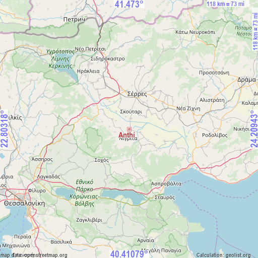
Anthí GPS coordinates[2]
40° 56' 38.508" North, 23° 30' 22.68" East
| Map corner | latitude | longitude |
|---|---|---|
| Upper-left | 41.473°, | 22.80318° |
| Center: | 40.94403°, | 23.5063° |
| Lower-right: | 40.41079°, | 24.20943° |
| Map W x H: | 118.1×118.1 km | = 73.4×73.4mi |
| max Lat: | 41.72048° ⇑10.1% North |
| Anthí: | 40.94403° |
| min Lat: | ⇓89.9% South 34.8346° |
| min Long | Anthí | max Long |
| 19.40494° | 23.5063° | 29.59361° |
| W 64.8%⇐ | ⇒35.2% E |
Elevation
Elevation of Anthí is 20 m = 66 ft, and this is 148.9 m = 489 ft below average elevation for this country.
| Max E: |
1439 m = 4721 ft | 77.6% |
| Avg. | 168.9 m = 554 ft | |
| Anthí | 20 m = 66 ft | |
Min E: |
0 m = 0 ft | 22.4% |
See also: Greece elevation on elevation.city.
Geographical zone
Anthí is located in North temperate zone (between Tropic of Cancer and the Arctic Circle). Distance of this Northern Tropic circle is 1946.6 km =1209.6 mi to South.| Distance of | km | miles | from Anthí |
|---|---|---|---|
| North Pole | 5454.5 | 3389.3 | to North |
| Arctic Circle | 2848.6 | 1770 | to North |
| Tropic Cancer | 1946.6 | 1209.6 | to South |
| Equator | 4552.5 | 2828.8 | to South |


Nearby cities:
15 places around Anthí: (largest is in red/bold)
• Achinós
12.9 km =8 mi,  101°
101°
• Agía Paraskeví
4.2 km =2.6 mi,  278°
278°
• Dimitrítsi
9 km =5.6 mi,  300°
300°
• Flámpouro
5.3 km =3.3 mi,  105°
105°
• Káto Kamíla
8.8 km =5.5 mi,  347°
347°
• Neochóri
13.5 km =8.4 mi,  27°
27°
• Nigríta
4.3 km =2.7 mi,  187°
187°
• Nikókleia
6.7 km =4.2 mi,  259°
259°
• Néos Skopós
12.4 km =7.7 mi,  44°
44°
• Psychikó
12.3 km =7.6 mi,  57°
57°
• Sitochóri
11.7 km =7.3 mi,  126°
126°
• Skoútari
8.4 km =5.2 mi,  7°
7°
• Terpní
3.7 km =2.3 mi,  214°
214°
• Valtotópi
9.3 km =5.8 mi,  53°
53°
• Vérgi
9.1 km =5.7 mi, 276°
Sources, notices
• [Note1] Compared only with cities in Greece existing in our database
• [Src1] Map data: © OpenStreetMap contributors (CC-BY-SA)
• [Src2] Other city data from geonames.org with taken over terms of usage.
• [Src3] Geographical zone / Annual Mean Temperature by Robert A. Rohde @ Wikipedia
