Mitroúsi geodata
Mitroúsi (Central Macedonia) is a populated place; located in Greece in Europe/Athens (GMT+3) time zone. With population of 1,479 people, there are 674 cities with bigger population in this country. Compared to other cities in Greece, 94.4% of cities are located further ↓South; 63.9% of cities are located further ←West and 79.3% of cities have higher elevation than Mitroúsi. Note1


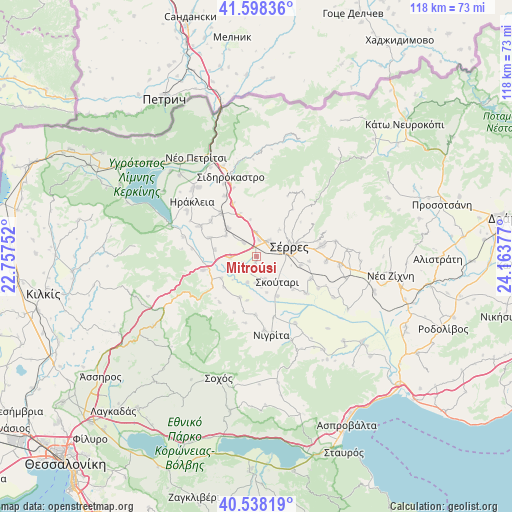
Mitroúsi GPS coordinates[2]
41° 4' 13.476" North, 23° 27' 38.304" East
| Map corner | latitude | longitude |
|---|---|---|
| Upper-left | 41.59836°, | 22.75752° |
| Center: | 41.07041°, | 23.46064° |
| Lower-right: | 40.53819°, | 24.16377° |
| Map W x H: | 117.9×117.9 km | = 73.3×73.3mi |
| max Lat: | 41.72048° ⇑5.6% North |
| Mitroúsi: | 41.07041° |
| min Lat: | ⇓94.4% South 34.8346° |
| min Long | Mitroúsi | max Long |
| 19.40494° | 23.46064° | 29.59361° |
| W 63.9%⇐ | ⇒36.1% E |
Elevation
Elevation of Mitroúsi is 18 m = 59 ft, and this is 150.9 m = 495 ft below average elevation for this country.
| Max E: |
1439 m = 4721 ft | 79.3% |
| Avg. | 168.9 m = 554 ft | |
| Mitroúsi | 18 m = 59 ft | |
Min E: |
0 m = 0 ft | 20.7% |
See also: Greece elevation on elevation.city.
Geographical zone
Mitroúsi is located in North temperate zone (between Tropic of Cancer and the Arctic Circle). Distance of this Northern Tropic circle is 1960.7 km =1218.3 mi to South.| Distance of | km | miles | from Mitroúsi |
|---|---|---|---|
| North Pole | 5440.5 | 3380.6 | to North |
| Arctic Circle | 2834.6 | 1761.3 | to North |
| Tropic Cancer | 1960.7 | 1218.3 | to South |
| Equator | 4566.6 | 2837.6 | to South |


Nearby cities:
15 places around Mitroúsi: (largest is in red/bold)
• Dimitrítsi
10.3 km =6.4 mi,  202°
202°
• Kalá Déndra
4.5 km =2.8 mi,  316°
316°
• Káto Kamíla
5.8 km =3.6 mi,  160°
160°
• Lefkónas
4.5 km =2.8 mi,  42°
42°
• Melenikítsi
8.8 km =5.5 mi,  351°
351°
• Neochóri
10.2 km =6.3 mi,  101°
101°
• Néa Tirolóï
8.5 km =5.3 mi,  304°
304°
• Palaiókastro
10.3 km =6.4 mi,  337°
337°
• Provatás
5.9 km =3.7 mi,  267°
267°
• Skotoússa
9.2 km =5.7 mi,  314°
314°
• Skoútari
7.6 km =4.7 mi,  139°
139°
• Sérres
7.5 km =4.7 mi,  77°
77°
• Vamvakiá
9.7 km =6 mi,  278°
278°
• Ágios Ioánnis
10.5 km =6.5 mi,  71°
71°
• Áno Kamíla
3.4 km =2.1 mi,  244°
244°
Sources, notices
• [Note1] Compared only with cities in Greece existing in our database
• [Src1] Map data: © OpenStreetMap contributors (CC-BY-SA)
• [Src2] Other city data from geonames.org with taken over terms of usage.
• [Src3] Geographical zone / Annual Mean Temperature by Robert A. Rohde @ Wikipedia
