Platanórevma geodata
Platanórevma (West Macedonia) is a populated place; located in Greece in Europe/Athens (GMT+3) time zone. With population of 1,112 people, there are 907 cities with bigger population in this country. Compared to other cities in Greece, 68.5% of cities are located further ↓South; 71.6% of cities are located further →East and 88.5% of cities have lower elevation than Platanórevma. Note1
Administrative division(s):
- Level 1: West Macedonia
- Level 2: Nomós Kozánis
- Level 3: Dimos Servia-Velventos


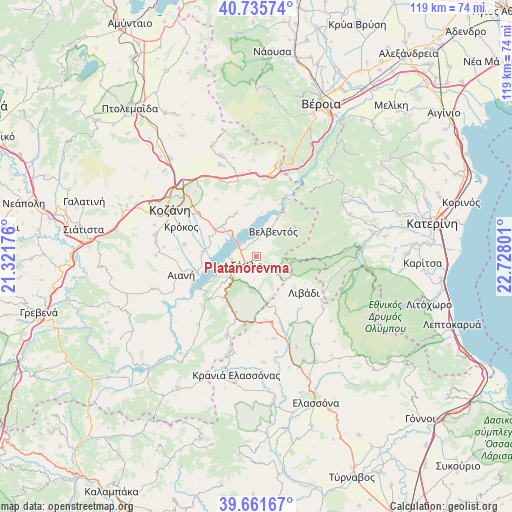
Platanórevma GPS coordinates[2]
40° 12' 2.988" North, 22° 1' 29.568" East
| Map corner | latitude | longitude |
|---|---|---|
| Upper-left | 40.73574°, | 21.32176° |
| Center: | 40.20083°, | 22.02488° |
| Lower-right: | 39.66167°, | 22.72801° |
| Map W x H: | 119.4×119.4 km | = 74.2×74.2mi |
| max Lat: | 41.72048° ⇑31.5% North |
| Platanórevma: | 40.20083° |
| min Lat: | ⇓68.5% South 34.8346° |
| min Long | Platanórevma | max Long |
| 19.40494° | 22.02488° | 29.59361° |
| W 28.4%⇐ | ⇒71.6% E |
Elevation
Elevation of Platanórevma is 474 m = 1555 ft, and this is 305.1 m = 1001 ft above average elevation for this country.
| Max E: |
1439 m = 4721 ft | 11.5% |
| Platanórevma | 474 m 1555 ft | |
| Avg. | 168.9 m = 554 ft | |
Min E: |
0 m = 0 ft | 88.5% |
See also: Greece elevation on elevation.city.
Geographical zone
Platanórevma is located in North temperate zone (between Tropic of Cancer and the Arctic Circle). Distance of this Northern Tropic circle is 1864 km =1158.2 mi to South.| Distance of | km | miles | from Platanórevma |
|---|---|---|---|
| North Pole | 5537.1 | 3440.6 | to North |
| Arctic Circle | 2931.3 | 1821.4 | to North |
| Tropic Cancer | 1864 | 1158.2 | to South |
| Equator | 4469.9 | 2777.5 | to South |


Nearby cities:
15 places around Platanórevma: (largest is in red/bold)
• Aianí
17.9 km =11.1 mi,  256°
256°
• Kastaniá
2.9 km =1.8 mi,  181°
181°
• Kozáni
22.9 km =14.2 mi,  299°
299°
• Krókos
18.9 km =11.7 mi,  291°
291°
• Livaderó
19.8 km =12.3 mi,  200°
200°
• Livádi
14 km =8.7 mi,  126°
126°
• Nea Lava
1.5 km =0.9 mi,  220°
220°
• Polýmylos
19.3 km =12 mi,  10°
10°
• Rizómata
22.9 km =14.2 mi,  43°
43°
• Sarantáporo
15 km =9.3 mi,  170°
170°
• Sérvia
3.5 km =2.2 mi,  227°
227°
• Velventós
7.4 km =4.6 mi, 35°
• Ágios Dimítrios
18.2 km =11.3 mi,  106°
106°
• Áno Kómi
16.9 km =10.5 mi,  279°
279°
• Ázoros
22.7 km =14.1 mi, 168°
Sources, notices
• [Note1] Compared only with cities in Greece existing in our database
• [Src1] Map data: © OpenStreetMap contributors (CC-BY-SA)
• [Src2] Other city data from geonames.org with taken over terms of usage.
• [Src3] Geographical zone / Annual Mean Temperature by Robert A. Rohde @ Wikipedia
