Kastaniá geodata
Kastaniá (West Macedonia) is a populated place; located in Greece in Europe/Athens (GMT+3) time zone. With population of 534 people, there are 1730 cities with bigger population in this country. Compared to other cities in Greece, 68.1% of cities are located further ↓South; 71.7% of cities are located further →East and 99.5% of cities have lower elevation than Kastaniá. Note1
Administrative division(s):
- Level 1: West Macedonia
- Level 2: Nomós Kozánis
- Level 3: Dimos Servia-Velventos


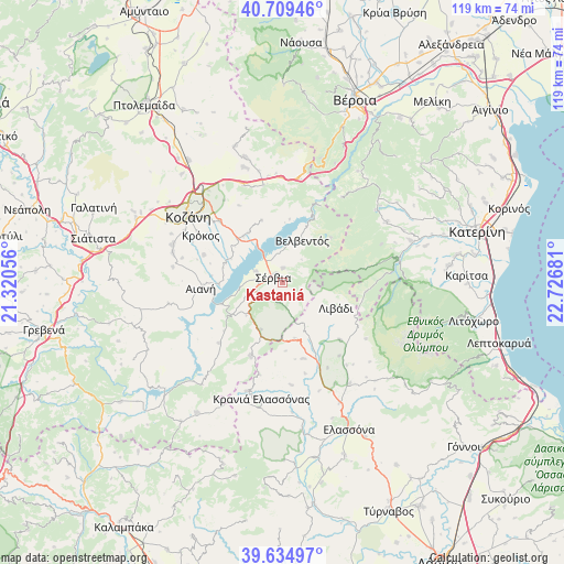
Kastaniá GPS coordinates[2]
40° 10' 27.624" North, 22° 1' 25.248" East
| Map corner | latitude | longitude |
|---|---|---|
| Upper-left | 40.70946°, | 21.32056° |
| Center: | 40.17434°, | 22.02368° |
| Lower-right: | 39.63497°, | 22.72681° |
| Map W x H: | 119.5×119.5 km | = 74.3×74.3mi |
| max Lat: | 41.72048° ⇑31.9% North |
| Kastaniá: | 40.17434° |
| min Lat: | ⇓68.1% South 34.8346° |
| min Long | Kastaniá | max Long |
| 19.40494° | 22.02368° | 29.59361° |
| W 28.3%⇐ | ⇒71.7% E |
Elevation
Elevation of Kastaniá is 977 m = 3205 ft, and this is 808.1 m = 2651 ft above average elevation for this country.
| Max E: |
1439 m = 4721 ft | 0.5% |
| Kastaniá | 977 m 3205 ft | |
| Avg. | 168.9 m = 554 ft | |
Min E: |
0 m = 0 ft | 99.5% |
See also: Greece elevation on elevation.city.
Geographical zone
Kastaniá is located in North temperate zone (between Tropic of Cancer and the Arctic Circle). Distance of this Northern Tropic circle is 1861 km =1156.4 mi to South.| Distance of | km | miles | from Kastaniá |
|---|---|---|---|
| North Pole | 5540.1 | 3442.5 | to North |
| Arctic Circle | 2934.2 | 1823.2 | to North |
| Tropic Cancer | 1861 | 1156.4 | to South |
| Equator | 4467 | 2775.7 | to South |


Nearby cities:
15 places around Kastaniá: (largest is in red/bold)
• Aianí
17.4 km =10.8 mi,  266°
266°
• Krókos
20.1 km =12.5 mi,  299°
299°
• Livaderó
17 km =10.6 mi,  203°
203°
• Livádi
12.6 km =7.8 mi,  115°
115°
• Loutró
24.3 km =15.1 mi, 198°
• Nea Lava
2 km =1.2 mi,  333°
333°
• Platanórevma
2.9 km =1.8 mi,  1°
1°
• Polýmylos
22.2 km =13.8 mi,  9°
9°
• Pýthio
21.4 km =13.3 mi, 124°
• Sarantáporo
12.1 km =7.5 mi,  168°
168°
• Sérvia
2.6 km =1.6 mi,  283°
283°
• Velventós
10 km =6.2 mi,  26°
26°
• Ágios Dimítrios
17.7 km =11 mi,  96°
96°
• Áno Kómi
17.6 km =10.9 mi,  289°
289°
• Ázoros
19.9 km =12.4 mi, 166°
Sources, notices
• [Note1] Compared only with cities in Greece existing in our database
• [Src1] Map data: © OpenStreetMap contributors (CC-BY-SA)
• [Src2] Other city data from geonames.org with taken over terms of usage.
• [Src3] Geographical zone / Annual Mean Temperature by Robert A. Rohde @ Wikipedia
