Polýmylos geodata
Polýmylos (West Macedonia) is a populated place; located in Greece in Europe/Athens (GMT+3) time zone. With population of 695 people, there are 1418 cities with bigger population in this country. Compared to other cities in Greece, 71.4% of cities are located further ↓South; 70.5% of cities are located further →East and 98.3% of cities have lower elevation than Polýmylos. Note1


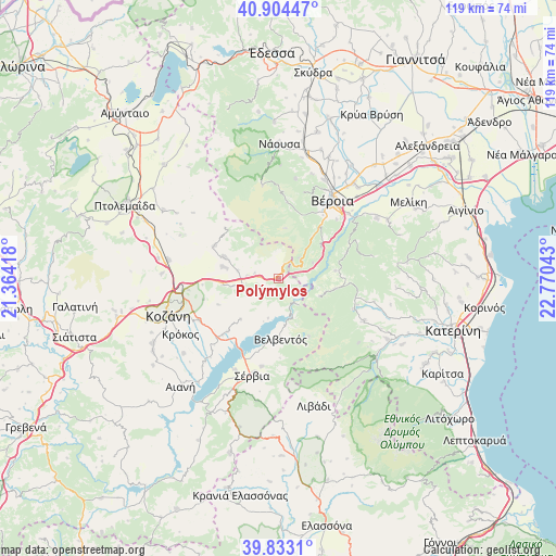
Polýmylos GPS coordinates[2]
40° 22' 15.276" North, 22° 4' 2.28" East
| Map corner | latitude | longitude |
|---|---|---|
| Upper-left | 40.90447°, | 21.36418° |
| Center: | 40.37091°, | 22.0673° |
| Lower-right: | 39.8331°, | 22.77043° |
| Map W x H: | 119.1×119.1 km | = 74×74mi |
| max Lat: | 41.72048° ⇑28.6% North |
| Polýmylos: | 40.37091° |
| min Lat: | ⇓71.4% South 34.8346° |
| min Long | Polýmylos | max Long |
| 19.40494° | 22.0673° | 29.59361° |
| W 29.5%⇐ | ⇒70.5% E |
Elevation
Elevation of Polýmylos is 869 m = 2851 ft, and this is 700.1 m = 2297 ft above average elevation for this country.
| Max E: |
1439 m = 4721 ft | 1.7% |
| Polýmylos | 869 m 2851 ft | |
| Avg. | 168.9 m = 554 ft | |
Min E: |
0 m = 0 ft | 98.3% |
See also: Greece elevation on elevation.city.
Geographical zone
Polýmylos is located in North temperate zone (between Tropic of Cancer and the Arctic Circle). Distance of this Northern Tropic circle is 1882.9 km =1170 mi to South.| Distance of | km | miles | from Polýmylos |
|---|---|---|---|
| North Pole | 5518.2 | 3428.8 | to North |
| Arctic Circle | 2912.3 | 1809.6 | to North |
| Tropic Cancer | 1882.9 | 1170 | to South |
| Equator | 4488.8 | 2789.2 | to South |


Nearby cities:
15 places around Polýmylos: (largest is in red/bold)
• Agía Varvára
20.4 km =12.7 mi,  47°
47°
• Akriní
15.4 km =9.6 mi,  297°
297°
• Elatochori
17.1 km =10.6 mi,  109°
109°
• Fyteía
21.7 km =13.5 mi,  9°
9°
• Kleítos
19 km =11.8 mi,  290°
290°
• Moschopótamos
21.1 km =13.1 mi,  103°
103°
• Nea Lava
20.6 km =12.8 mi,  192°
192°
• Platanórevma
19.3 km =12 mi, 190°
• Ritíni
20.5 km =12.7 mi,  116°
116°
• Rizómata
12.4 km =7.7 mi, 100°
• Ráchi
17.7 km =11 mi,  44°
44°
• Sfikiá
12.1 km =7.5 mi,  82°
82°
• Sérvia
22.1 km =13.7 mi,  196°
196°
• Velventós
12.9 km =8 mi,  176°
176°
• Véroia
20.5 km =12.7 mi,  33°
33°
Sources, notices
• [Note1] Compared only with cities in Greece existing in our database
• [Src1] Map data: © OpenStreetMap contributors (CC-BY-SA)
• [Src2] Other city data from geonames.org with taken over terms of usage.
• [Src3] Geographical zone / Annual Mean Temperature by Robert A. Rohde @ Wikipedia
