Sarantáporo geodata
Sarantáporo (Thessaly) is a populated place; located in Greece in Europe/Athens (GMT+3) time zone. With population of 938 people, there are 1083 cities with bigger population in this country. Compared to other cities in Greece, 67.4% of cities are located further ↓South; 70.8% of cities are located further →East and 98% of cities have lower elevation than Sarantáporo. Note1


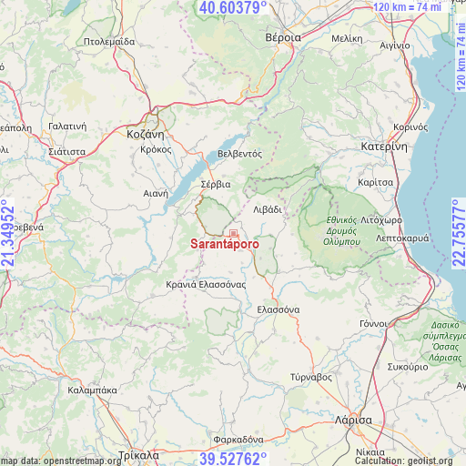
Sarantáporo GPS coordinates[2]
40° 4' 4.188" North, 22° 3' 9.504" East
| Map corner | latitude | longitude |
|---|---|---|
| Upper-left | 40.60379°, | 21.34952° |
| Center: | 40.06783°, | 22.05264° |
| Lower-right: | 39.52762°, | 22.75577° |
| Map W x H: | 119.7×119.7 km | = 74.4×74.4mi |
| max Lat: | 41.72048° ⇑32.6% North |
| Sarantáporo: | 40.06783° |
| min Lat: | ⇓67.4% South 34.8346° |
| min Long | Sarantáporo | max Long |
| 19.40494° | 22.05264° | 29.59361° |
| W 29.2%⇐ | ⇒70.8% E |
Elevation
Elevation of Sarantáporo is 837 m = 2746 ft, and this is 668.1 m = 2192 ft above average elevation for this country.
| Max E: |
1439 m = 4721 ft | 2% |
| Sarantáporo | 837 m 2746 ft | |
| Avg. | 168.9 m = 554 ft | |
Min E: |
0 m = 0 ft | 98% |
See also: Greece elevation on elevation.city.
Geographical zone
Sarantáporo is located in North temperate zone (between Tropic of Cancer and the Arctic Circle). Distance of this Northern Tropic circle is 1849.2 km =1149 mi to South.| Distance of | km | miles | from Sarantáporo |
|---|---|---|---|
| North Pole | 5551.9 | 3449.8 | to North |
| Arctic Circle | 2946 | 1830.6 | to North |
| Tropic Cancer | 1849.2 | 1149 | to South |
| Equator | 4455.1 | 2768.3 | to South |


Nearby cities:
15 places around Sarantáporo: (largest is in red/bold)
• Elassóna
22.5 km =14 mi,  148°
148°
• Eláti
21.9 km =13.6 mi,  243°
243°
• Kalývia
16.8 km =10.4 mi,  107°
107°
• Kastaniá
12.1 km =7.5 mi,  348°
348°
• Kraniá Elassónas
14.7 km =9.1 mi,  208°
208°
• Livaderó
10.1 km =6.3 mi,  248°
248°
• Livádi
11 km =6.8 mi,  53°
53°
• Loutró
15.1 km =9.4 mi,  222°
222°
• Nea Lava
14 km =8.7 mi, 346°
• Platanórevma
15 km =9.3 mi, 350°
• Pýthio
15.2 km =9.4 mi,  90°
90°
• Sérvia
13.4 km =8.3 mi,  338°
338°
• Velventós
20.9 km =13 mi,  5°
5°
• Ágios Dimítrios
18 km =11.2 mi,  57°
57°
• Ázoros
7.8 km =4.8 mi,  163°
163°
Sources, notices
• [Note1] Compared only with cities in Greece existing in our database
• [Src1] Map data: © OpenStreetMap contributors (CC-BY-SA)
• [Src2] Other city data from geonames.org with taken over terms of usage.
• [Src3] Geographical zone / Annual Mean Temperature by Robert A. Rohde @ Wikipedia
