Oreiní geodata
Oreiní (Central Macedonia) is a populated place; located in Greece in Europe/Athens (GMT+3) time zone. With population of 742 people, there are 1344 cities with bigger population in this country. Compared to other cities in Greece, 97.7% of cities are located further ↓South; 66.3% of cities are located further ←West and 96.6% of cities have lower elevation than Oreiní. Note1


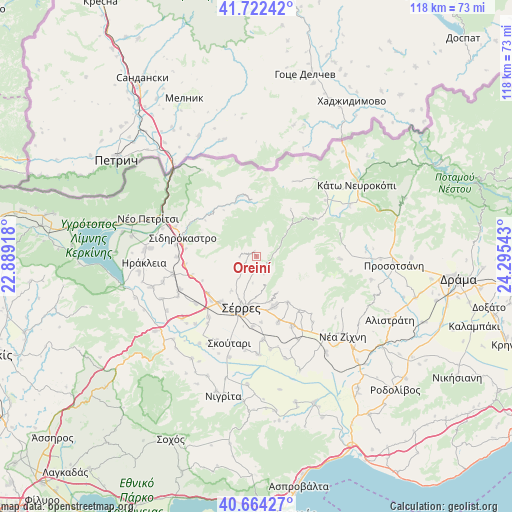
Oreiní GPS coordinates[2]
41° 11' 43.728" North, 23° 35' 32.28" East
| Map corner | latitude | longitude |
|---|---|---|
| Upper-left | 41.72242°, | 22.88918° |
| Center: | 41.19548°, | 23.5923° |
| Lower-right: | 40.66427°, | 24.29543° |
| Map W x H: | 117.7×117.7 km | = 73.1×73.1mi |
| max Lat: | 41.72048° ⇑2.3% North |
| Oreiní: | 41.19548° |
| min Lat: | ⇓97.7% South 34.8346° |
| min Long | Oreiní | max Long |
| 19.40494° | 23.5923° | 29.59361° |
| W 66.3%⇐ | ⇒33.7% E |
Elevation
Elevation of Oreiní is 756 m = 2480 ft, and this is 587.1 m = 1926 ft above average elevation for this country.
| Max E: |
1439 m = 4721 ft | 3.4% |
| Oreiní | 756 m 2480 ft | |
| Avg. | 168.9 m = 554 ft | |
Min E: |
0 m = 0 ft | 96.6% |
See also: Greece elevation on elevation.city.
Geographical zone
Oreiní is located in North temperate zone (between Tropic of Cancer and the Arctic Circle). Distance of this Northern Tropic circle is 1974.6 km =1227 mi to South.| Distance of | km | miles | from Oreiní |
|---|---|---|---|
| North Pole | 5426.6 | 3371.9 | to North |
| Arctic Circle | 2820.7 | 1752.7 | to North |
| Tropic Cancer | 1974.6 | 1227 | to South |
| Equator | 4580.5 | 2846.2 | to South |


Nearby cities:
15 places around Oreiní: (largest is in red/bold)
• Achladochóri
14.5 km =9 mi,  342°
342°
• Chrysó
16.1 km =10 mi,  162°
162°
• Emmanouíl Pappás
15.7 km =9.8 mi,  141°
141°
• Eptámyloi
10.5 km =6.5 mi,  180°
180°
• Lefkónas
13.3 km =8.3 mi,  217°
217°
• Melenikítsi
13.4 km =8.3 mi,  246°
246°
• Monóvrysi
15.1 km =9.4 mi, 175°
• Neochóri
16 km =9.9 mi, 183°
• Néo Soúli
12.1 km =7.5 mi, 159°
• Oinoússa
10.7 km =6.6 mi, 164°
• Palaiókastro
15.6 km =9.7 mi, 253°
• Sérres
12.8 km =8 mi,  196°
196°
• Vamvakófyto
16.5 km =10.3 mi,  263°
263°
• Ágio Pnévma
12.8 km =8 mi, 144°
• Ágios Ioánnis
10.7 km =6.6 mi,  185°
185°
Sources, notices
• [Note1] Compared only with cities in Greece existing in our database
• [Src1] Map data: © OpenStreetMap contributors (CC-BY-SA)
• [Src2] Other city data from geonames.org with taken over terms of usage.
• [Src3] Geographical zone / Annual Mean Temperature by Robert A. Rohde @ Wikipedia
