Melenikítsi geodata
Melenikítsi (Central Macedonia) is a populated place; located in Greece in Europe/Athens (GMT+3) time zone. With population of 621 people, there are 1546 cities with bigger population in this country. Compared to other cities in Greece, 96.8% of cities are located further ↓South; 63.4% of cities are located further ←West and 63.6% of cities have lower elevation than Melenikítsi. Note1
Administrative division(s):
- Level 1: Central Macedonia
- Level 2: Nomós Serrón
- Level 3: Dimos Irakleia


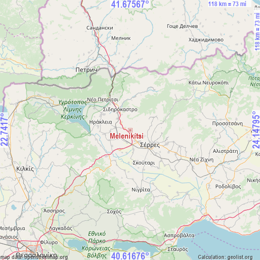
Melenikítsi GPS coordinates[2]
41° 8' 54.06" North, 23° 26' 41.352" East
| Map corner | latitude | longitude |
|---|---|---|
| Upper-left | 41.67567°, | 22.7417° |
| Center: | 41.14835°, | 23.44482° |
| Lower-right: | 40.61676°, | 24.14795° |
| Map W x H: | 117.7×117.7 km | = 73.1×73.1mi |
| max Lat: | 41.72048° ⇑3.2% North |
| Melenikítsi: | 41.14835° |
| min Lat: | ⇓96.8% South 34.8346° |
| min Long | Melenikítsi | max Long |
| 19.40494° | 23.44482° | 29.59361° |
| W 63.4%⇐ | ⇒36.6% E |
Elevation
Elevation of Melenikítsi is 134 m = 440 ft, and this is 34.9 m = 115 ft below average elevation for this country.
| Max E: |
1439 m = 4721 ft | 36.4% |
| Avg. | 168.9 m = 554 ft | |
| Melenikítsi | 134 m = 440 ft | |
Min E: |
0 m = 0 ft | 63.6% |
See also: Greece elevation on elevation.city.
Geographical zone
Melenikítsi is located in North temperate zone (between Tropic of Cancer and the Arctic Circle). Distance of this Northern Tropic circle is 1969.3 km =1223.7 mi to South.| Distance of | km | miles | from Melenikítsi |
|---|---|---|---|
| North Pole | 5431.8 | 3375.2 | to North |
| Arctic Circle | 2825.9 | 1755.9 | to North |
| Tropic Cancer | 1969.3 | 1223.7 | to South |
| Equator | 4575.3 | 2843 | to South |


Nearby cities:
15 places around Melenikítsi: (largest is in red/bold)
• Ammoudhiá
9.2 km =5.7 mi,  266°
266°
• Anayénnisis
10.3 km =6.4 mi,  245°
245°
• Chorteró
10.2 km =6.3 mi,  321°
321°
• Gefyroúdi
7.1 km =4.4 mi,  279°
279°
• Kalá Déndra
5.7 km =3.5 mi,  197°
197°
• Lefkónas
6.9 km =4.3 mi,  140°
140°
• Mitroúsi
8.8 km =5.5 mi,  171°
171°
• Néa Tirolóï
6.9 km =4.3 mi,  235°
235°
• Palaiókastro
2.8 km =1.7 mi,  288°
288°
• Provatás
10 km =6.2 mi,  207°
207°
• Sidirókastro
10.7 km =6.6 mi,  334°
334°
• Skotoússa
5.7 km =3.5 mi, 247°
• Vamvakiá
10.9 km =6.8 mi,  229°
229°
• Vamvakófyto
5.3 km =3.3 mi,  309°
309°
• Áno Kamíla
10.3 km =6.4 mi,  189°
189°
Sources, notices
• [Note1] Compared only with cities in Greece existing in our database
• [Src1] Map data: © OpenStreetMap contributors (CC-BY-SA)
• [Src2] Other city data from geonames.org with taken over terms of usage.
• [Src3] Geographical zone / Annual Mean Temperature by Robert A. Rohde @ Wikipedia
