Vamvakófyto geodata
Vamvakófyto (Central Macedonia) is a populated place; located in Greece in Europe/Athens (GMT+3) time zone. With population of 1,061 people, there are 951 cities with bigger population in this country. Compared to other cities in Greece, 97.2% of cities are located further ↓South; 62.3% of cities are located further ←West and 51.7% of cities have higher elevation than Vamvakófyto. Note1


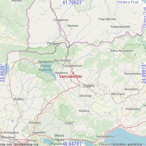
Vamvakófyto GPS coordinates[2]
41° 10' 44.976" North, 23° 23' 45.672" East
| Map corner | latitude | longitude |
|---|---|---|
| Upper-left | 41.70623°, | 22.6929° |
| Center: | 41.17916°, | 23.39602° |
| Lower-right: | 40.64781°, | 24.09915° |
| Map W x H: | 117.7×117.7 km | = 73.1×73.1mi |
| max Lat: | 41.72048° ⇑2.8% North |
| Vamvakófyto: | 41.17916° |
| min Lat: | ⇓97.2% South 34.8346° |
| min Long | Vamvakófyto | max Long |
| 19.40494° | 23.39602° | 29.59361° |
| W 62.3%⇐ | ⇒37.7% E |
Elevation
Elevation of Vamvakófyto is 75 m = 246 ft, and this is 93.9 m = 308 ft below average elevation for this country.
| Max E: |
1439 m = 4721 ft | 51.7% |
| Avg. | 168.9 m = 554 ft | |
| Vamvakófyto | 75 m = 246 ft | |
Min E: |
0 m = 0 ft | 48.3% |
See also: Greece elevation on elevation.city.
Geographical zone
Vamvakófyto is located in North temperate zone (between Tropic of Cancer and the Arctic Circle). Distance of this Northern Tropic circle is 1972.8 km =1225.8 mi to South.| Distance of | km | miles | from Vamvakófyto |
|---|---|---|---|
| North Pole | 5428.4 | 3373.1 | to North |
| Arctic Circle | 2822.5 | 1753.8 | to North |
| Tropic Cancer | 1972.8 | 1225.8 | to South |
| Equator | 4578.7 | 2845.1 | to South |


Nearby cities:
15 places around Vamvakófyto: (largest is in red/bold)
• Ammoudhiá
6.5 km =4 mi,  231°
231°
• Anayénnisis
9.4 km =5.8 mi,  214°
214°
• Charopó
9.2 km =5.7 mi,  347°
347°
• Chorteró
5 km =3.1 mi,  333°
333°
• Gefyroúdi
3.6 km =2.2 mi, 232°
• Irákleia
9.5 km =5.9 mi,  272°
272°
• Kalá Déndra
9.2 km =5.7 mi,  165°
165°
• Karperí
9.3 km =5.8 mi,  235°
235°
• Koímisi
8.8 km =5.5 mi,  295°
295°
• Melenikítsi
5.3 km =3.3 mi,  129°
129°
• Néa Tirolóï
7.5 km =4.7 mi,  192°
192°
• Palaiókastro
2.9 km =1.8 mi,  150°
150°
• Sidirókastro
6.2 km =3.9 mi, 354°
• Skotoússa
5.8 km =3.6 mi, 191°
• Valteró
6.3 km =3.9 mi, 270°
Sources, notices
• [Note1] Compared only with cities in Greece existing in our database
• [Src1] Map data: © OpenStreetMap contributors (CC-BY-SA)
• [Src2] Other city data from geonames.org with taken over terms of usage.
• [Src3] Geographical zone / Annual Mean Temperature by Robert A. Rohde @ Wikipedia
