Vérgi geodata
Vérgi (Central Macedonia) is a populated place; located in Greece in Europe/Athens (GMT+3) time zone. With population of 699 people, there are 1415 cities with bigger population in this country. Compared to other cities in Greece, 90.4% of cities are located further ↓South; 62.4% of cities are located further ←West and 63.2% of cities have higher elevation than Vérgi. Note1
Administrative division(s):
- Level 1: Central Macedonia
- Level 2: Nomós Serrón
- Level 3: Dimos Visaltia


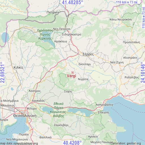
Vérgi GPS coordinates[2]
40° 57' 14.256" North, 23° 23' 53.988" East
| Map corner | latitude | longitude |
|---|---|---|
| Upper-left | 41.48285°, | 22.69521° |
| Center: | 40.95396°, | 23.39833° |
| Lower-right: | 40.4208°, | 24.10146° |
| Map W x H: | 118.1×118.1 km | = 73.4×73.4mi |
| max Lat: | 41.72048° ⇑9.6% North |
| Vérgi: | 40.95396° |
| min Lat: | ⇓90.4% South 34.8346° |
| min Long | Vérgi | max Long |
| 19.40494° | 23.39833° | 29.59361° |
| W 62.4%⇐ | ⇒37.6% E |
Elevation
Elevation of Vérgi is 43 m = 141 ft, and this is 125.9 m = 413 ft below average elevation for this country.
| Max E: |
1439 m = 4721 ft | 63.2% |
| Avg. | 168.9 m = 554 ft | |
| Vérgi | 43 m = 141 ft | |
Min E: |
0 m = 0 ft | 36.8% |
See also: Greece elevation on elevation.city.
Geographical zone
Vérgi is located in North temperate zone (between Tropic of Cancer and the Arctic Circle). Distance of this Northern Tropic circle is 1947.7 km =1210.2 mi to South.| Distance of | km | miles | from Vérgi |
|---|---|---|---|
| North Pole | 5453.4 | 3388.6 | to North |
| Arctic Circle | 2847.5 | 1769.4 | to North |
| Tropic Cancer | 1947.7 | 1210.2 | to South |
| Equator | 4553.7 | 2829.5 | to South |


Nearby cities:
15 places around Vérgi: (largest is in red/bold)
• Agía Paraskeví
5 km =3.1 mi,  95°
95°
• Anthí
9.1 km =5.7 mi, 96°
• Dimitrítsi
3.7 km =2.3 mi,  20°
20°
• Flámpouro
14.4 km =8.9 mi, 100°
• Káto Kamíla
10.3 km =6.4 mi,  43°
43°
• Mitroúsi
14 km =8.7 mi, 21°
• Nigríta
10.1 km =6.3 mi,  122°
122°
• Nikókleia
3.4 km =2.1 mi,  133°
133°
• Provatás
12.7 km =7.9 mi,  356°
356°
• Skoútari
12.5 km =7.8 mi,  54°
54°
• Strymonikó
12 km =7.5 mi,  324°
324°
• Terpní
8.1 km =5 mi, 120°
• Triantafylliá
5.4 km =3.4 mi,  308°
308°
• Vamvakiá
15.1 km =9.4 mi,  343°
343°
• Áno Kamíla
11.7 km =7.3 mi,  10°
10°
Sources, notices
• [Note1] Compared only with cities in Greece existing in our database
• [Src1] Map data: © OpenStreetMap contributors (CC-BY-SA)
• [Src2] Other city data from geonames.org with taken over terms of usage.
• [Src3] Geographical zone / Annual Mean Temperature by Robert A. Rohde @ Wikipedia
